 OSURIS
SNO H+ : Time-Lapse Seismic and Electrical Monitoring of the Vadose Zone during a Controlled Infiltration Experiment at the Ploemeur Hydrological Observatory France
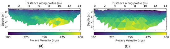
The vadose zone is the main host of surface and subsurface water exchange and has important implications for ecosystems functioning,climate sciences,geotechnical engineering,and water availability issues. Geophysics provides a means for investigating the subsurface in a non-invasive way and at larger spatial scales than conventional hydrological sensors. Time-lapse hydrogeophysical applications are especially useful for monitoring flow and water content dynamics. Largely dominated by electrical and electromagnetic methods,such applications increasingly rely on seismic methods as a complementary approach to describe the structure and behavior of the vadose zone. To further explore the applicability of active seismics to retrieve quantitative information about dynamic processes in near-surface time-lapse settings,we designed a controlled water infiltration experiment at the Ploemeur Hydrological Observatory (France) during which successive periods of infiltration were followed by surface-based seismic and electrical resistivity acquisitions. Water content was monitored throughout the experiment by means of sensors at different depths to relate the derived seismic and electrical properties to water saturation changes. We observe comparable trends in the electrical and seismic responses during the experiment,highlighting the utility of the seismic method to monitor hydrological processes and unsaturated flow. Moreover,petrophysical relationships seem promising in providing quantitative results.
Simple
- Date (Création)
- 2021-01-01
- Identificateur
- SNO-HPLUS-BLAZEVIC-ET-AL
- Forme de la présentation
- Carte numérique
- Fréquence de mise à jour
- Lorsque nécessaire
- Nom
- text/csv
-
Inspire
-
Gemet
-
Continents, countries, sea regions of the world
-
-
france
-
brittany
-
-
Keywords
-
-
hydrogeophysics
-
seismic
-
electric imaging
-
time elapse
-
vadose zone
-
water saturation
-
infiltration
-
- Limitation d'utilisation
-
CC BY-NC-SA International 4.0
- Contraintes d'accès
- Restricted
- Contraintes d'utilisation
- Licence
- Autres contraintes
-
Ask for the supplier for the accuracy,updating,integrity and completeness of the data. Access and use of H+ data policy are subject to H+ data policy,please see the agreements on H+ web site : http://hplus.ore.fr/public/Terms_and_agreements_Hplus_README_en.pdf
- Langue
- English
- Jeu de caractères
- Utf8
- Catégorie ISO
-
- Sciences de la terre, géosciences
- Environnement
- Eaux intérieures, Hydrographie
))
- Date de début
- 2020
- Date de fin
- 2020
- Nom du système de référence
- EPSG / 4326
- Ressource en ligne
- Data on H+ data ( WWW:LINK-1.0-http--link )
- Ressource en ligne
- Information on H+ website ( WWW:LINK-1.0-http--link )
- Ressource en ligne
- Ploemeur_ERT_Blazevic_etal_Water_2020 ( WWW:DOWNLOAD-1.0-http--download )
- Ressource en ligne
- Ploemeur_Water_Content_Blazevic_etal_Water_2020 ( WWW:DOWNLOAD-1.0-http--download )
- Ressource en ligne
- Ploemeur_Seismic_Blazevic_etal_Water_2020 ( WWW:DOWNLOAD-1.0-http--download )
- Protocole
-
WWW:LINK-1.0-http--link
- Nom
-
publication[Time-Lapse Seismic and Electrical Monitoring of the Vadose Zone during a Controlled Infiltration Experiment at the Ploemeur Hydrological Observatory
- Niveau
- Jeu de données
- Généralités sur la provenance
-
Measurements:
- Identifiant de la fiche
- SNO-HPLUS-BLAZEVIC-ET-AL XML
- Langue
- English
- Jeu de caractères
- Utf8
- Identifiant de la fiche de métadonnées parent
- 3d54-4322-9af9-06e8701a78da
- Type de ressource
- Jeu de données
- Date des métadonnées
- 2024-06-26T15:09:50
- Nom du standard de métadonnées
-
ISO 19115:2003 Geographic information - Metadata
- Version du standard de métadonnées
-
ISO 19115:2003
- Désignation de la donnée (URI)
-
SNO-HPLUS-BLAZEVIC-ET-AL
Aperçus
Étendue spatiale
Fourni par
