OSURIS
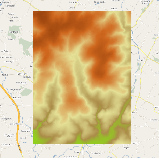
MNT à 25 mètres de résolution (BD Alti) de Naizin
Modèle Numérique de Terrain (MNT) à 25 mètres de résolution extrait de la BD ALTI Version 2.0 de l'IGN à 25 mètres de résolution. L'emprise géographique du MNT correspond au site de l'Observatoire de Recherche en Environnement (ORE) AgrHyS de Naizin dans le Morbihan.
Simple
- Date (Publication)
- 2020-11-19
- Edition
-
1.0
- Identificateur
- fr-130005127-umrsas-ore-nzn_mnt_ign_25m
- But
-
Proposer aux scientifiques un MNT "prêt à l'emploi" pour les travaux de modélisation
- Etat
- Finalisé
- Fréquence de mise à jour
- Lorsque nécessaire
- Thème
-
-
ORE AgrHys
-
MNT
-
BD Alti
-
Données ouvertes
-
-
external.place.localisation
-
-
France
-
-
UMR SAS Themes
-
-
Altimétrie
-
-
INSPIRE themes
-
-
Altitude
-
- Limitation d'utilisation
-
Usage libre sous réserve des mentions obligatoires sur tout document de diffusion : "Source : • copyright « © IGN – 2021 »"
- Limitation d'utilisation
-
Licence ouverte V2.0 : https://www.etalab.gouv.fr/wp-content/uploads/2017/04/ETALAB-Licence-Ouverte-v2.0.pdf
- Contraintes d'accès
- Autres restrictions
- Contraintes d'utilisation
- Licence
- Type de représentation spatiale
- Raster
- Distance de résolution
- 10 m
- Langue
-
fre
- Catégorie ISO
-
- Altimétrie
- Description
-
France
))
- Nom du système de référence
- EPSG / RGF93 / Lambert-93 (EPSG:2154) / 7.5.0.1
- Format (encodage)
-
-
GeoTIFF
(
1.0
)
-
GeoTIFF
(
1.0
)
Distributeur
- Nom
-
raster
- Version
-
1.0
- Ressource en ligne
-
nzn_mnt_ign_25m
(
OGC:WMS
)
Modèle Numérique de Terrain à 25 mètres de résolution de Naizin
- Ressource en ligne
- télécharger le MNT au format GEOTIFF ( WWW:DOWNLOAD-1.0-http--download )
- Niveau
- Jeu de données
Résultat de conformité
- Date (Création)
- 2014-02-01
- Explication
-
Non Evalué
- Degré de conformité
- Oui
- Généralités sur la provenance
-
Ce modèle numérique de terrain est extrait de la BD Alti Version 2.0 de l'IGN à 25 mètres de résolution
- Identifiant de la fiche
- c199a6d9-6b85-4aee-9793-dde0b384b757 XML
- Langue
-
fre
- Jeu de caractères
- Utf8
- Type de ressource
- Jeu de données
- Date des métadonnées
- 2024-12-23T12:36:34
- Nom du standard de métadonnées
-
ISO 19115
- Version du standard de métadonnées
-
1.0