 OSURIS
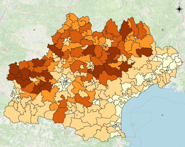
Projet Artisols - Coefficient de dispersion par canton - Occitanie - 2015 à 2019
Le coefficient de dispersion représente le rapport entre la surface des espaces artificialisés (taches urbaines) morcelés, définis ici pour une emprise inférieure à 3 hectares, et celle des espaces artificialisés denses supérieurs ou égales à 3 hectares.Cet indicateur a été calculé par canton et pour les années 2015 à 2019.
Simple
- Date (Révision)
- 2022-05-17T19:10:21
- Edition
-
1.0
- Date d'édition
- 2015-01-01
- Identificateur
- f69abf04-45a2-4bdb-b79d-50a6a001646c
- But
-
Cet indicateur permet d’évaluer l’influence du phénomène de mitage en analysant la tendance au morcellement ou à la compacité d’un territoire. Plus il est élevé, plus la tendance du territoire est au mitage et à la dispersion des espaces artificialisés. Il peut être également intéressant de suivre cette évolution dans le temps.
- Etat
- Finalisé
- Fréquence de mise à jour
- Non planifiée
-
General
-
-
Urban sprawl
-
- Limitation d'utilisation
-
This work is licensed under a Creative Commons Attribution 4.0 License (CC BY 4.0, https://creativecommons.org/licenses/by/4.0).
- Contraintes d'accès
- Licence
- Contraintes d'utilisation
- Licence
- Restrictions de manipulation
- Non classifié
- Explications sur les restrictions
-
unclassified
- Système de classification
-
no classification in particular
- Description de manipulation
-
description
- Type de représentation spatiale
- Vecteur
- Langue
- Français
- Jeu de caractères
- Utf8
- Catégorie ISO
-
- Carte de référence de la couverture terrestre
))
- Date de début
- 2019-01-01T00:00:00Z
- Date de fin
- 2019-12-31T00:00:00Z
- Informations supplémentaires
-
some additional information
- Nom du système de référence
- EPSG / 2154
- Format (encodage)
-
-
GPKG
(
1.0
)
-
GPKG
(
1.0
)
- Ressource en ligne
- DOI Coefficient de dispersion ( file for download )
- Ressource en ligne
-
cantons_coef_Disp
(
OGC:WMS
)
WMS Service
- Niveau
- Jeu de données
Résultat de conformité
- Autres appellations ou acronymes
-
This is is some data quality check report
- Date (Publication)
- 2022-05-17T19:10:21
- Explication
-
some explanation about the conformance
- Degré de conformité
- Oui
Résultat de conformité
- Date (Publication)
- 2010-12-08T12:00:00
- Explication
-
See the referenced specification
- Degré de conformité
- Oui
Résultat de conformité
- Date (Publication)
- 2008-12-04T12:00:00
- Explication
-
See the referenced specification
- Degré de conformité
- Oui
- Généralités sur la provenance
-
Ce coefficient est calculé en faisant le rapport entre la surface des espaces artificialisés (taches urbaines) morcelés, définis ici pour une emprise inférieure à 3 hectares, et celle des espaces artificialisés denses supérieurs ou égales à 3 hectares.
- Identifiant de la fiche
- f69abf04-45a2-4bdb-b79d-50a6a001646c XML
- Langue
- English
- Jeu de caractères
- Utf8
- Identifiant de la fiche de métadonnées parent
-
ArtiSols Project
0f2bb3f7-7094-407c-9082-184b667aa577
- Type de ressource
- Jeu de données
- Date des métadonnées
- 2022-05-17T19:21:43
- Nom du standard de métadonnées
-
ISO 19115:2003/19139
- Version du standard de métadonnées
-
1.0
Aperçus
Étendue spatiale
Fourni par
