 OSURIS
Sol
GEMET keywords
Type of resources
Available actions
Topics
INSPIRE themes
Keywords
Contact for the resource
Provided by
Years
Formats
Representation types
Update frequencies
status
Scale
Resolution
-

"Modern Earth Observation systems provide huge amount of data from different sensors at different temporal, spatialand spectral resolutions. Such amount of information is commonly represented by means of multispectral imagery and, due to its complexity, it requires new techniques and method to be correctly exploited to extract valuable knowledge.Recently, data science and, in particular, machine (and deep) learning algorithms have demonstrated their ability to cope with image and signal analysis providing cutting-edge results. Multiple data science challenges were already launched using satellite imagery (i.e. building footprints, road networks, iceberg detection, etc…) but crucial open questions remain unsolved (i.e. biodiversity monitoring, urban mapping, deforestation tracking and food risk prevention, triaging disaster zones, etc..). We are at the beginning of a new era for the analysis of Earth Observation data (EOD) where one of the main question is how to leverage the complementarity and the diversity of the different Earth Observation systems to answer important social challenges and monitor changes on the Earth Surface.The MDL4EO team (Machine and Deep Learning for Earth Observation) at the UMR TETIS (Montpellier, France) has the objective to scientifically contribute to this new era providing AI methods and algorithms to extract valuable knowledge from modern Earth Observation Data. The amount of data being collected by remote sensors is accelerating rapidly and we cannot manage them manually, this is why machine/deep learning lends itself well to remote sensing. More in detail, some of the research questions of the MDL4EO team are the follows:How to intelligently exploit Time Series of Satellite Images to leverage temporal dynamics How to combine/fusion together multi spectral/temporal/resolution/sensor information with the objective to add value to the information thanks to the combination of multi source How to transfer knowledge from different geographical Area: transfer land cover classification model from one site (i.e. France) to another one geographically distant (i.e. Africa). It’s time to fill the gap between Remote Sensing and AI. MDL4EO is working on that direction bringing together different expertises: Data Science, Computer Vision, Machine Learning, Remote Sensing and Geoinformatics."
-

"Le CES “Humidité du sol à très haute résolution spatiale”propose de nouvelles cartes d’humidité du sol sur la région Occitanie à l’échelle sub-parcellaire élaborées tous les 6 jours de septembre 2017 à mars 2018.Les données utilisées sont issues des séries d’images Copernicus radar Sentinelle 1 et optique Sentinelle 2. L’algorithme d’inversion du signal radar utilise les réseaux de neurones. Il est appliqué sur les parcelles agricoles (avec ou sans végétation) extraites de la carte d’occupation des sols 2016 élaborée par le CES Occupation des sols de Theia (Jordi Inglada et al.)."
-

A very high spatial resolution Land Use and Land Cover map was produced for the greater Marino watershed (Peru) using the MORINGA processing chain. The methods involved multisource satellite imagery and a random forest model, as well as manual post-treatment. The final map provides important information for environmental management and monitoring and contributes to developing standardized methodologies for accurate LULC mapping. Training Dataset
-

A very high spatial resolution Land Use and Land Cover map was produced for the greater Marino watershed (Peru) using the MORINGA processing chain. The methods involved multisource satellite imagery and a random forest model, as well as manual post-treatment. The final map provides important information for environmental management and monitoring and contributes to developing standardized methodologies for accurate LULC mapping. Classification 2019 – Level 2
-

A very high spatial resolution Land Use and Land Cover map was produced for the greater Marino watershed (Peru) using the MORINGA processing chain. The methods involved multisource satellite imagery and a random forest model, as well as manual post-treatment. The final map provides important information for environmental management and monitoring and contributes to developing standardized methodologies for accurate LULC mapping. Classification 2019 – Level 1
-

A very high spatial resolution Land Use and Land Cover map was produced for the greater Marino watershed (Peru) using the MORINGA processing chain. The methods involved multisource satellite imagery and a random forest model, as well as manual post-treatment. The final map provides important information for environmental management and monitoring and contributes to developing standardized methodologies for accurate LULC mapping. Classification 2019 – Level 3
-
A very high spatial resolution Land Use and Land Cover map was produced for the greater Marino watershed (Peru) using the MORINGA processing chain. The methods involved multisource satellite imagery and a random forest model, as well as manual post-treatment. The final map provides important information for environmental management and monitoring and contributes to developing standardized methodologies for accurate LULC mapping. 3 levels are available with the training dataset
-
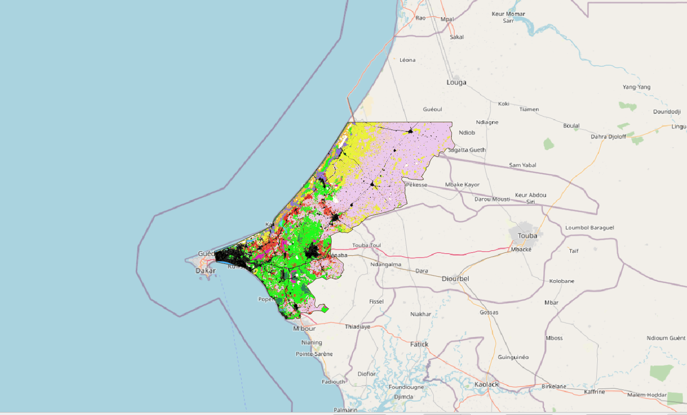
La zone d'étude se situe au nord ouest du Sénégal et s'étale sur 5 100km². Elle inclue la ville de Thiès et une partie de la ville de Dakar, et remonte jusqu'à Kébémer, aux portes du désert de Loumpoul. La carte d'occupation 2018 a été réalisée à partir d'une image à Très Haute Résolution Spatiale (THRS) à 1.5m Spot6 acquise le 15/10/2010 et une série temporelle d'images Sentinel2 (résolution 10m) acquises entre le 01/01/2018 et le 31/12/2018. Le traitement a été réalisé via la chaine de traitement Moringa développée dans l'UMR TETIS. La méthodologie s'appuie sur une Segmentation Orientée Objet de l'image THRS puis d'une classification de chaque polygone (algorithme Random Forest) s'appuyant sur l'image SPOT6, la série temporelle Sentinel2, le SRTM à 30m et de nombreux indices calculés à partir de ces images (NDVI, indices de texture, pente,...). L’algorithme a été entrainé via un jeu de données acquises sur le terrain complété de données obtenues par photo-interprétation. Des corrections manuelles par photo-interprétation ont été réalisées afin d'améliorer le résultat. La précision globale est de 93%. La classification contient 13 classes d'occupation du sol : culture irriguée hors bas-fond, culture irriguée de bas-fond, culture pluviale, plantation, dune sable - arbustes, eau, savane arbustive, savane herbacée, sol nu, sol inondable, sol faiblement végétalisé, végétation naturelle dense et zone urbaine.
-
Titre: Un millénaire d’interactions entre sociétés et leurs environnements en Arctique et Subarctique (Canada et Groenland). Résumé Le projet InterArctic est centré sur la vulnérabilité, la résilience et l'adaptation de sociétés humaines nordiques face aux changements globaux. L'actuel réchauffement rapide du climat arctique a déjà entrainé de nombreux changements dans les comportements sociaux, économiques et culturels des populations habitant ces régions et plus de changements sont à venir. Ces changements perturbent le fragile équilibre entre sociétés et environnement. Les populations arctiques doivent faire face à ces challenges et, dans un tel contexte, observer et étudier les événements du passé donnent l'opportunité d'explorer les relations complexes entre climat, écologie et sociétés humaines, qui peuvent aider à proposer des scénarios d'évolution selon certaines prévisions. Le cadre chronologique de ce projet couvre le dernier millénaire, une période assez bien documentée. La région d'étude concerne le nord-est du Canada (Nunavik et Labrador-Nunatsiavut) et le Groenland (nord et sud). Il y a environ 1000 ans cal. AD. Certains territoires de ces régions, furent témoins de la rencontre des fermiers européens provenant de la Scandinavie et des chasseurs-cueilleurs-pêcheurs provenant de la Béringie. Présentement, ces deux styles de vie continuent à coexister, avec des activités agricoles dans le sud de Groenland et la chasse, la pêche et la cueillette sur les côtes de Nunavut, du Nunavik et du Labrador et du nord de Groenland. Dans ces secteurs d'étude, notre but est de documenter 1000 ans d'interactions entre les Thule/Inuit (Dorset pro parte) et les Norois et leur environnement à travers une approche interdisciplinaire exploitant toute une variété d'archives sédimentaires. L'exploitation des archives pédo-sédimentaires (dépôts lacustres et tourbeux, cryosols, sols anthropisés) et les analyses multiproxies paléoenvironnementales renseigneront sur l'évolution paysagère et sur la part prise par les forçages climatiques et anthropiques sur les processus écologiques. Les sites archéologiques et plus spécifiquement les sols archéologiques, les écofacts et artefacts trouvés en leur sein livreront de précieuses informations sur la nature de ces interactions. En parallèle quand cela sera possible, une approche en géographie culturelle sera conduite selon des interviews semi-dirigés pour enquêter sur la mémoire humaine des aînés, la perception et les perspectives en matière de changements environnementaux et sociaux. Plusieurs modes de diffusion des connaissances acquises par Inter sont identifiés et adaptés aux diverses audiences et partenaires : académiques (communications dans colloques, et articles dans revues internationales), communautés et autorités locales. C'est une priorité pour nous de disséminer les résultats de nos travaux sur le terrain et en laboratoire auprès d'un public non-spécialiste, tout particulièrement en direction de la jeunesse vivant dans les communautés Inuit, selon un site web interactif et une page Facebook. Mots clés : Arctique, Subarctique, Groenland, Nunavik, Labrador-Nunatsiavut, Canada, Norois, Fermes, Interactions Homme-milieu, Thule, Inuit, Archives naturelles, Établissements archéologiques, Artefacts archéologiques, Matières premières, Changements climatiques, Environnements, Paysage, Écosystèmes, Biodiversité, Changements globaux, Changements sociaux, Flore, Faune, Sols, ADN ancien, Perception, Mémoire, Héritages, Holocène, Dernier millénaire.