 OSURIS
series
Type of resources
Available actions
Topics
Keywords
Contact for the resource
Provided by
Years
Formats
Representation types
Update frequencies
status
Scale
-
Titre: Un millénaire d’interactions entre sociétés et leurs environnements en Arctique et Subarctique (Canada et Groenland). Résumé Le projet InterArctic est centré sur la vulnérabilité, la résilience et l'adaptation de sociétés humaines nordiques face aux changements globaux. L'actuel réchauffement rapide du climat arctique a déjà entrainé de nombreux changements dans les comportements sociaux, économiques et culturels des populations habitant ces régions et plus de changements sont à venir. Ces changements perturbent le fragile équilibre entre sociétés et environnement. Les populations arctiques doivent faire face à ces challenges et, dans un tel contexte, observer et étudier les événements du passé donnent l'opportunité d'explorer les relations complexes entre climat, écologie et sociétés humaines, qui peuvent aider à proposer des scénarios d'évolution selon certaines prévisions. Le cadre chronologique de ce projet couvre le dernier millénaire, une période assez bien documentée. La région d'étude concerne le nord-est du Canada (Nunavik et Labrador-Nunatsiavut) et le Groenland (nord et sud). Il y a environ 1000 ans cal. AD. Certains territoires de ces régions, furent témoins de la rencontre des fermiers européens provenant de la Scandinavie et des chasseurs-cueilleurs-pêcheurs provenant de la Béringie. Présentement, ces deux styles de vie continuent à coexister, avec des activités agricoles dans le sud de Groenland et la chasse, la pêche et la cueillette sur les côtes de Nunavut, du Nunavik et du Labrador et du nord de Groenland. Dans ces secteurs d'étude, notre but est de documenter 1000 ans d'interactions entre les Thule/Inuit (Dorset pro parte) et les Norois et leur environnement à travers une approche interdisciplinaire exploitant toute une variété d'archives sédimentaires. L'exploitation des archives pédo-sédimentaires (dépôts lacustres et tourbeux, cryosols, sols anthropisés) et les analyses multiproxies paléoenvironnementales renseigneront sur l'évolution paysagère et sur la part prise par les forçages climatiques et anthropiques sur les processus écologiques. Les sites archéologiques et plus spécifiquement les sols archéologiques, les écofacts et artefacts trouvés en leur sein livreront de précieuses informations sur la nature de ces interactions. En parallèle quand cela sera possible, une approche en géographie culturelle sera conduite selon des interviews semi-dirigés pour enquêter sur la mémoire humaine des aînés, la perception et les perspectives en matière de changements environnementaux et sociaux. Plusieurs modes de diffusion des connaissances acquises par Inter sont identifiés et adaptés aux diverses audiences et partenaires : académiques (communications dans colloques, et articles dans revues internationales), communautés et autorités locales. C'est une priorité pour nous de disséminer les résultats de nos travaux sur le terrain et en laboratoire auprès d'un public non-spécialiste, tout particulièrement en direction de la jeunesse vivant dans les communautés Inuit, selon un site web interactif et une page Facebook. Mots clés : Arctique, Subarctique, Groenland, Nunavik, Labrador-Nunatsiavut, Canada, Norois, Fermes, Interactions Homme-milieu, Thule, Inuit, Archives naturelles, Établissements archéologiques, Artefacts archéologiques, Matières premières, Changements climatiques, Environnements, Paysage, Écosystèmes, Biodiversité, Changements globaux, Changements sociaux, Flore, Faune, Sols, ADN ancien, Perception, Mémoire, Héritages, Holocène, Dernier millénaire.
-
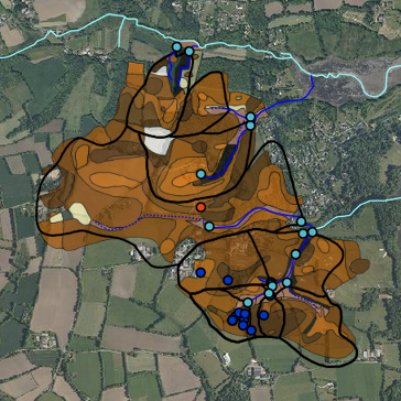
Le site de Kerbernez est localisé dans le sud du Finistère et occupe une surface de 1.28 km². Il est composé de 6 bassins de premier ordre et d’un bassin du deuxième ordre : Nead Meur (0.135 km²), Pont Lenn (0.117 km²), Coat Timon (0.57 km²), Le Puits (0.37 km²), Kerbernez (0.12 km²), Kerrien (0.095 km²). Les deux derniers sont des sous bassins du Puits. L’altitude varie entre 10 et 55 m NGF, avec des pentes modérées (moins de 7%) mais localement parfois supérieures à 15%. Les différents cours d’eau se jettent dans l’Odet 10 km avant son embouchure dans l’Atlantique.
-
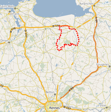
L’entité bocagère de la Zone Atelier Armorique (ZAAR) est située au niveau du canton de Pleine-Fougères (depuis 1993). La zone bocagère est caractérisée par un gradient paysager allant d’un bocage dense avec des parcelles petites bordées de haies à un bocage lâche. Les haies bordant les parcelles sont le plus souvent constituées d’arbres émondés en ragosses, de chênes avec parfois quelques châtaigniers émondés et des chênes en haut jet, mais aussi de cépées de châtaigniers. Depuis 2005, en raison de l’introduction de conditions de protection de l’environnement dans la Politique Agricole Commune, la plupart des cours d’eau sont bordés de bandes enherbées.
-
AgrHyS est un Observatoire de Recherche en Environnement (ORE) labellise par le Ministere de la Recherche en 2002, et un des observatoires de l'Infrastructure de Recherche nationale et distribuee OZCAR (Observatoires de la Zone Critique, Applications, Recherche) labellisee par le Ministere de la Recherche en 2017. Il est géré par L'INRA (UMRSAS à Rennes). Il a pour objectif d’étudier les temps de réponse des flux hydrogeochimiques à l'évolution des agro-hydrosystemes. Il étudie en particulier les agro-hydrosystèmes de milieux tempérés humides, dominés par une activité de polyculture-élevage.
-
Collection de couches cartographiques d'occupation du sol de la Zone Atelier Armorique
-
Soere PRO: Observatoire de la valeur agronomique et des impacts environnementaux des produits résiduaires organiques recyclés en agriculture