 OSURIS
dataset
GEMET keywords
Type of resources
Available actions
Topics
INSPIRE themes
Keywords
Contact for the resource
Provided by
Years
Formats
Representation types
Update frequencies
status
Scale
Resolution
-
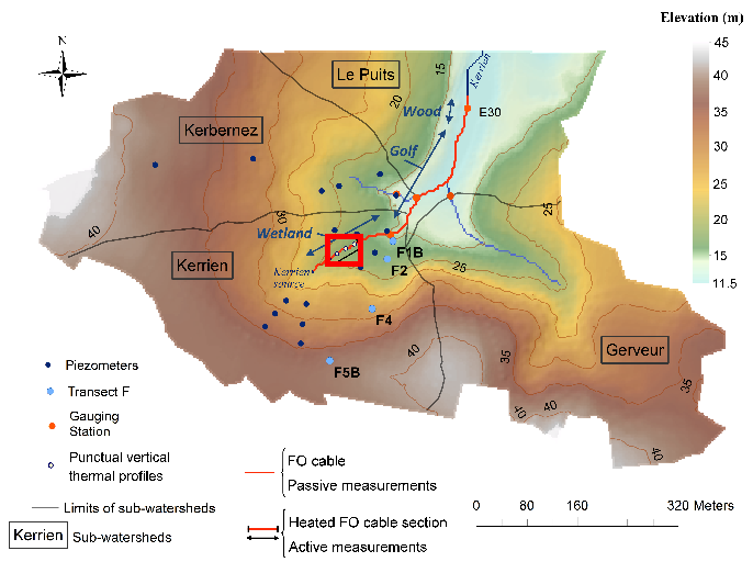
Data corresponding to the active-DTS experiment conducted in Kerrien by deploying and burying an heatable FO cable in the streambed sediments (in the wetland area). Further details are available in the file: http://agrhys.fr/BVE/nataline/mesuresactives/infos.pdf and results are presented in Simon et al. (2021)
-
La valeur médiane du pH par commune des sols Bretagne a été estimée pour la région Bretagne à partir du Référentiel Régional Pédologique de Bretagne. Le vecteur est composé de six bandes, correspondant aux valeurs médiane du pH à six profondeurs standards : 0-15 cm, 5-15 cm, 15-30 cm, 30-60 cm, 60-100 cm et 100-200 cm.
-

Des stations de mesure en continu de paramètres hydrologiques, physiques, chimiques et sédimentaires ont été installées sur le fleuve Sélune, dans le cadre du programme scientifique de suivi de l’arasement des barrages de la Sélune. Les mesures sont acquises avec une fréquence au moins horaire depuis au plus 2014. Depuis 2019, ces stations relèvent de l'Observatoire Sélune, qui est en charge du suivi des paramètres environnementaux (biotiques et abiotiques). Les paramètres physico-chimiques mesurés comportent sur toutes les stations : la turbidité, le niveau d’eau, la conductivité. Sur certaines des stations, le pH et l’oxygène dissous ou la concentration en chlorophylle sont mesurés en plus. Cette couche donne les mesures brutes, issues des stations de mesure hydrologique SIGNY, LA-ROCHE-QUI-BOIT, VIREY et DORIERE (uniquement jusque octobre 2020).
-
Image Aster uniquement géoréférencée de Barfleur dans la Manche et en grande partie de son littoral, composée de 3 bandes dans le visible et proche-infrarouge (0,556 à 0,807µm) et datant d'avril 2000.
-
Carte pédologique de Saint-Malo au 1/25000. La codification correspond au code 4 critères des sols du Massif armoricain (voir ressources en ligne). Les champs de la table attributaire sont : - SUB : Matériau(x) parental(ux) à partir du(des)quel(s) se développe le sol - HYD : Classe d'hydromorphie, de 0 (sol bien drainé) à 9 (sol extrêmement hydromorphie) - TYPE : Développement de profil défini à partir de la succession des horizons - PROF : Profondeur du sol, classée de 1 (sols très épais) à 6 (sols superficiels) - CODE4C : code 4 critères issu de la concaténation des champs précédents. Les valeurs prises par les différents champs pour chaque entité sont détaillées dans la méthode 4 critères (voir ressources en ligne). - UTS : Numéro d'Unité Typologique de Sol issue du Référentiel Régional Pédologique de Bretagne.
-
Image Aster uniquement géoréférencée du littoral du Calvados (14). Elle est composée de 3 bandes (1,6 à 2,43µm) en janvier 2001.
-
La proportion d'éléments grossiers des sols Bretagne a été estimée pour la région Bretagne à partir du Référentiel Régional Pédologique de Bretagne. Le raster est composé de six bandes, correspondant aux valeurs d'éléments grossiersà six profondeurs standards : 0-15 cm, 5-15 cm, 15-30 cm, 30-60 cm, 60-100 cm et 100-200 cm. Les valeurs sont exprimées en pourcentage.
-
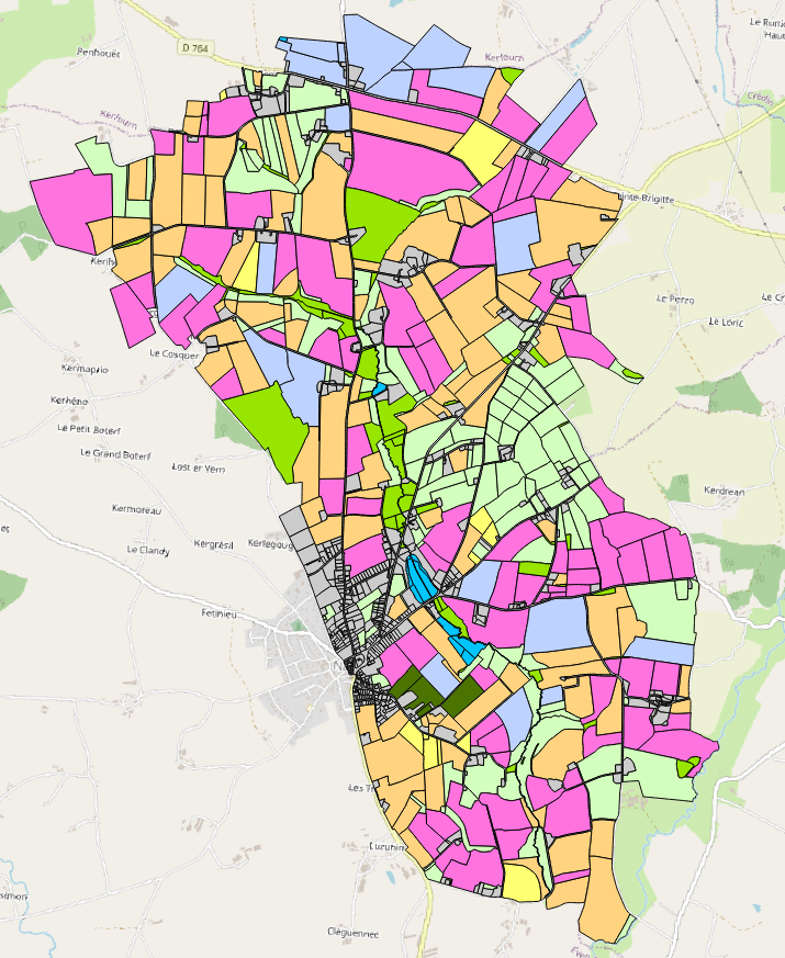
Occupation des sols 2012 du bassin versant du site de Naizin dans le Morbihan dans le cadre de l'Observatoire de Recherche en Environnement (ORE) AgrHyS d'INRAE. Le parcellaire est issu du cadastre de 2013. Les dessertes ont été redessinées à partir des orthophotos IGN de 2013 et le parcellaire a été découpé en fonction d’une zone tampon autour de ces dessertes. Les parcelles 2013 peuvent être découpées mais jamais regroupées. Toutes les entités géographiques élémentaires ont un identifiant unique sur l’ensemble des années. Champs de la table d’attribut : • ID_2012 : identifiant de la parcelle pour l’année 2012 • TYPE_12 : code principal de l’occupation des sols • S_TYPE_12 : code secondaire de l’occupation des sols • NUM_ILOT : identifiant numérique et non significatif par îlot du RPG 2012 • CODE_GROUP : code des cultures de l’îlot regroupées du RPG 2012 La nomenclature de ces codes des types et sous-types a été définie dans le programme ANR-12-AGRO-0005 MOSAIC : https://anr.fr/Projet-ANR-12-AGRO-0005. Leurs descriptions peuvent être télécharger ici : https://geosas.fr/metadata/ore/xls/legendes_osol_naizin.xlsx. Les occupations des sols sont issues des données par ilot du Registre Parcellaire Graphique (RPG) de l’année 2012. Les limites des parcelles ont été mises en concordance avec le parcellaire de 2013.
-
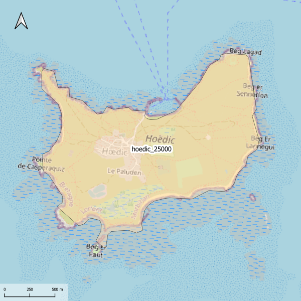
Emprise de la carte pédologique de l'île d'Hoedic au 1/25000. La donnée de base, au format image scannée, n'est pas publiée.
-
Occupation des sols 1995 du bassin versant du site de Naizin dans le Morbihan dans le cadre de l'Observatoire de Recherche en Environnement (ORE) AgrHyS d'INRAE. Le parcellaire est issu du cadastre de 2013. Les dessertes ont été redessinées à partir des orthophotos IGN de 2013 et le parcellaire a été découpé en fonction d’une zone tampon autour de ces dessertes. Les parcelles 2013 peuvent être découpées mais jamais regroupées. Toutes les entités géographiques élémentaires ont un identifiant unique sur l’ensemble des années. Champs de la table d’attribut : • ID_1995 : identifiant de la parcelle pour l’année 1995 • TYPE : code principal de l’occupation des sols • S_TYPE : code secondaire de l’occupation des sols La nomenclature de ces codes des types et sous-types a été définie dans le programme ANR-12-AGRO-0005 MOSAIC : https://anr.fr/Projet-ANR-12-AGRO-0005. Leurs descriptions peuvent être télécharger ici : https://geosas.fr/metadata/ore/xls/legendes_osol_naizin.xlsx. Les occupations des sols sont issues de photo-interprétation dans le cadre du programme CORMORAN (Cheverry et al., 1998). Les limites des parcelles ont été mises en concordance avec le parcellaire de 2013.