 OSURIS
asNeeded
GEMET keywords
Type of resources
Available actions
Topics
INSPIRE themes
Keywords
Contact for the resource
Provided by
Years
Formats
Representation types
Update frequencies
status
Scale
Resolution
-
Occupation des sols 2012 du bassin versant du site de Naizin dans le Morbihan dans le cadre de l'Observatoire de Recherche en Environnement (ORE) AgrHyS d'INRAE. Le parcellaire est issu du cadastre de 2013. Les dessertes ont été redessinées à partir des orthophotos IGN de 2013 et le parcellaire a été découpé en fonction d’une zone tampon autour de ces dessertes. Les parcelles 2013 peuvent être découpées mais jamais regroupées. Toutes les entités géographiques élémentaires ont un identifiant unique sur l’ensemble des années. Champs de la table d’attribut : • ID_2012 : identifiant de la parcelle pour l’année 2012 • TYPE_12 : code principal de l’occupation des sols • S_TYPE_12 : code secondaire de l’occupation des sols • NUM_ILOT : identifiant numérique et non significatif par îlot du RPG 2012 • CODE_GROUP : code des cultures de l’îlot regroupées du RPG 2012 La nomenclature de ces codes des types et sous-types a été définie dans le programme ANR-12-AGRO-0005 MOSAIC : https://anr.fr/Projet-ANR-12-AGRO-0005. Leurs descriptions peuvent être télécharger ici : https://geosas.fr/metadata/ore/xls/legendes_osol_naizin.xlsx. Les occupations des sols sont issues des données par ilot du Registre Parcellaire Graphique (RPG) de l’année 2012. Les limites des parcelles ont été mises en concordance avec le parcellaire de 2013.
-
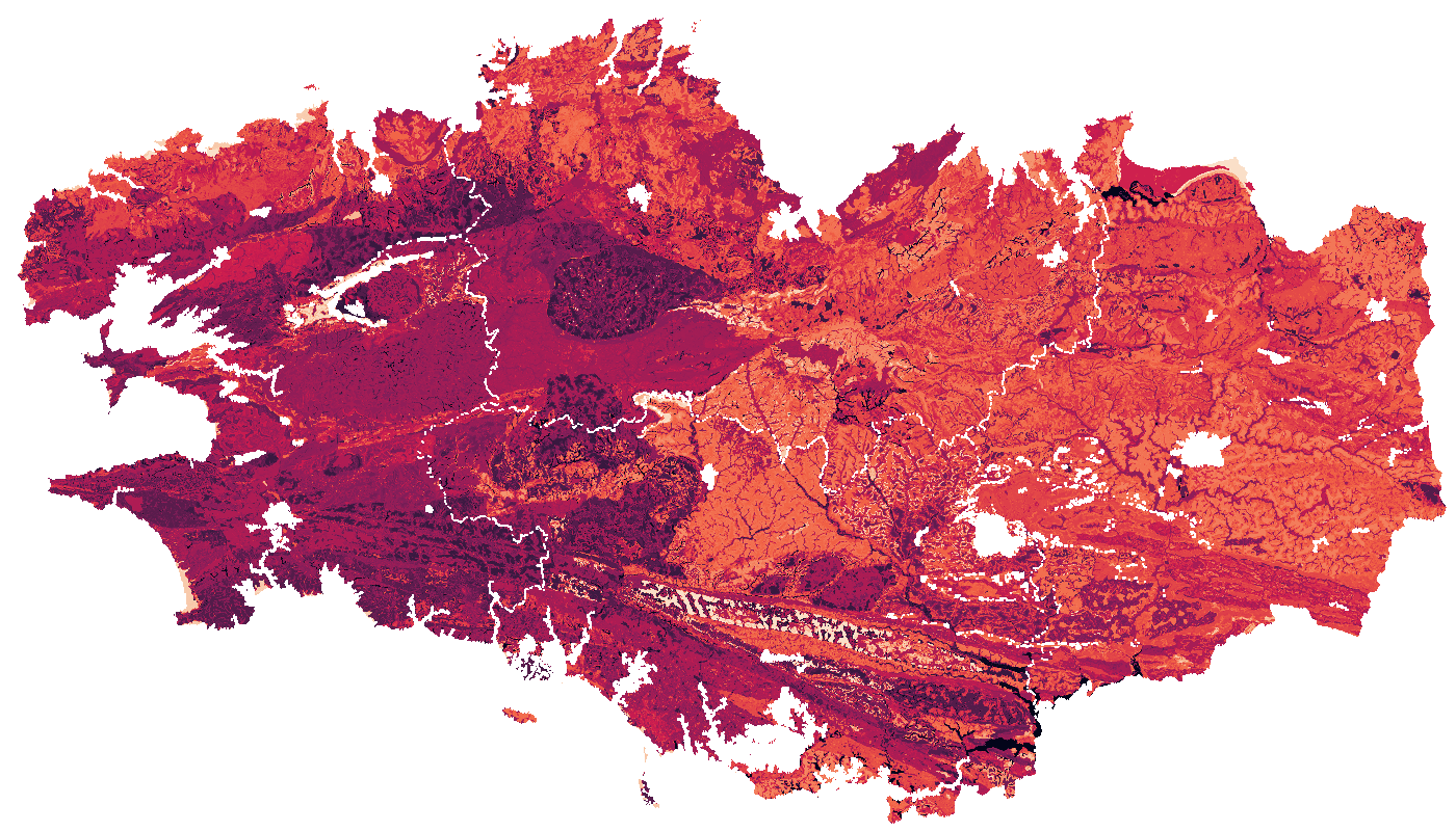
La CEC mesuré à l'eau des sols Bretagne a été estimée pour la région Bretagne à partir du Référentiel Régional Pédologique de Bretagne. Le raster est composé de six bandes, correspondant aux valeurs de la CEC à six profondeurs standards : 0-15 cm, 5-15 cm, 15-30 cm, 30-60 cm, 60-100 cm et 100-200 cm. Les valeurs sont exprimées en cmol+/kg.
-
Occupation des sols 2020 du bassin versant du site de Naizin dans le Morbihan dans le cadre de l'Observatoire de Recherche en Environnement (ORE) AgrHyS d'INRAE. Le parcellaire est issu du cadastre de 2013. Les dessertes ont été redessinées à partir des orthophotos IGN de 2013 et le parcellaire a été découpé en fonction d’une zone tampon autour de ces dessertes. Les parcelles 2013 peuvent être découpées mais jamais regroupées. Toutes les entités géographiques élémentaires ont un identifiant unique sur l’ensemble des années. Champs de la table d’attribut : • ID_2020 : identifiant de la parcelle pour l’année 2020 • TYPE_20 : code principal de l’occupation des sols • S_TYPE_20 : code secondaire de l’occupation des sols • ID_PARCEL : Identifiant numérique et non significatif par parcelle du RPG 2020 • CODE_GROUP : code du groupe de cultures du RPG 2020 • CODE_CULTU : code du groupe de cultures majoritaire du RPG 2020 • CULTURE_D1 : code de la culture dérobée (culture intercalée entre 2 moissons de culture principale) sur la parcelle. • CULTURE_D2 : code de la seconde culture dérobée (culture intercalée entre 2 moissons de culture principale). La nomenclature de ces codes des types et sous-types a été définie dans le programme ANR-12-AGRO-0005 MOSAIC : https://anr.fr/Projet-ANR-12-AGRO-0005. Leurs descriptions peuvent être télécharger ici : https://geosas.fr/metadata/ore/xls/legendes_osol_naizin.xlsx. Les occupations des sols sont issues des données par parcelles du Registre Parcellaire Graphique (RPG) de l’année 2020. Les limites des parcelles ont été mises en concordance avec le parcellaire de 2013.
-
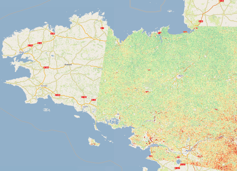
Estimation de l'humidité des sols de Bretagne représentée sous la forme d'une série temporelle d'images raster à 10 mètres de résolution entre janvier 2017 et décembre 2022. La méthode d’estimation de l’humidité, développée à l’INRAE (UMR TETIS), est basée sur l'utilisation d'images satellitaires des nouveaux systèmes d’observation de la Terre Copernicus radar et optique Sentinel-1 et Sentinel-2. Plus d'informations sur la méthode : https://geosas.fr/metadata/pdf/Livrable_TED_Bosco_Mars2022_Bretagne_INRAE_Baghdadi.pdf
-
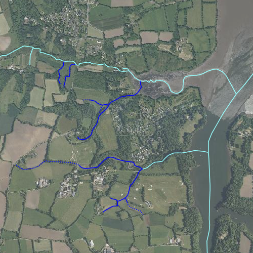
Représentation du réseau hydrographique sur la zone d'étude INRA de Kerbernez. Certains cours d'eau n'appartenant pas à la zone d'étude ont été représentés pour une meilleure compréhension du réseau. Les cours d'eau représentés en pointillés sont des cours d'eau alimentés moins de huit mois dans l'année, en traits pleins les cours d'eau alimentés plus de huit mois dans l'année. Le réseau hydrographique a été redessiné à partir d'une couche vecteur réalisée par Samuel Abiven (ABIVEN. S., 2000) et de l'ortho-photographie IGN. Les tracés ont été approuvés par Laurent Ruiz. Le code hydrographique a été renseigné à partir de la base de données Carthage.
-
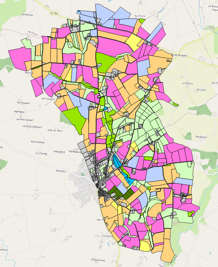
Occupation des sols 1997 du bassin versant du site de Naizin dans le Morbihan dans le cadre de l'Observatoire de Recherche en Environnement (ORE) AgrHyS d'INRAE. Le parcellaire est issu du cadastre de 2013. Les dessertes ont été redessinées à partir des orthophotos IGN de 2013 et le parcellaire a été découpé en fonction d’une zone tampon autour de ces dessertes. Les parcelles 2013 peuvent être découpées mais jamais regroupées. Toutes les entités géographiques élémentaires ont un identifiant unique sur l’ensemble des années. Champs de la table d’attribut : • ID_1997 : identifiant de la parcelle pour l’année 1997 • ID_IEA_97 : identifiant de l’exploitant pour l’année 1997 • TYPE : code principal de l’occupation des sols • S_TYPE : code secondaire de l’occupation des sols La nomenclature de ces codes des types et sous-types a été définie dans le programme ANR-12-AGRO-0005 MOSAIC : https://anr.fr/Projet-ANR-12-AGRO-0005. Leurs descriptions peuvent être télécharger ici : https://geosas.fr/metadata/ore/xls/legendes_osol_naizin.xlsx. Les occupations des sols sont issues de photo-interprétation dans le cadre du programme CORMORAN (Cheverry et al., 1998). Les limites des parcelles ont été mises en concordance avec le parcellaire de 2013.
-
Les données correspondent aux centroïdes des 40 parcelles agricoles en agriculture biologique et conventionnelle, suivies dans le projet DIVAG en 2019 dans la Zone Atelier Armorique Sud au Sud de l'Ille et Vilaine. Les données produites sont une couche vecteur polygone des points (contenant leurs coordonnées géographiques) correspondant aux centroïdes des parcelles. Programme de financement : projet DIVAG (Zone Atelier Armorique).
-
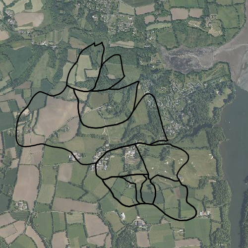
Représentation des contours de sous bassins versants de la zone d'étude INRA de Kerbernez. Le site comporte cinq sous bassins versants (Puits, Coat Timon, Ty Garde, Pont Lenn et Nead Meur). Le bassin du Puits est lui même divisé en trois sous bassins (Kerbernez, Kerrien et Guerveur). Le tracé des contours a été réalisé à partir de la carte IGN au 1/10000ème et des observations topographiques du terrain (NICOLAS. J.M., 1991). Ces contours ont été affinés par de nouvelles observations sur le terrain et reportés sur planches cadastrales au 1/2500ème (CHATELIER. J.M., 1995). Un calque des contours a ensuite été géoréférencé puis scanné (ABIVEN. S., 2000). A partir de ce calque l'image a été vectorisée sous QGIS et approuvée par Laurent RUIZ. Le sous bassin de Kerrien a été divisé en trois unités à partir d'un modèle numérique de terrain réalisé par le Lycée Agricole de Kerbernez (2006).
-
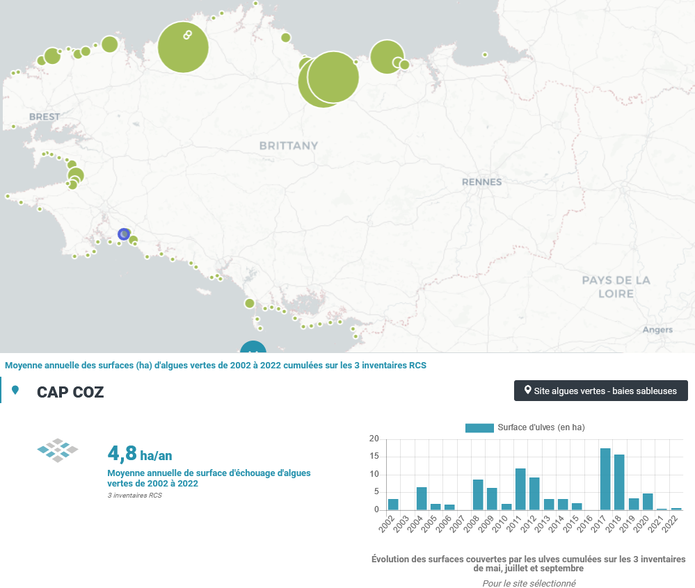
Le CEVA a été chargé, de 2002 à 2006, de la mise en place puis de la réalisation du suivi du phénomène de « marées vertes » à l’échelle de la Bretagne, dans le cadre du programme Prolittoral, programme régional et interdépartemental de lutte contre les marées vertes (financement de l’Agence de l’Eau Loire Bretagne, du Conseil régional de Bretagne et des quatre Conseils généraux bretons). Dans ce cadre, le CEVA a développé des outils spécifiques pour évaluer le phénomène et son évolution. Ces outils ont été élaborés en partant de la connaissance du phénomène acquise au travers des suivis antérieurs, réalisés pour le compte du Conseil général des Côtes d’Armor, de l’Agence de l’Eau Loire Bretagne et de collectivités locales bretonnes particulièrement touchées par le phénomène. Depuis 2007, le CEVA réalise les inventaires de marées vertes du Réseau de Contrôle de Surveillance (RCS) dans le cadre de la Directive Cadre sur l’Eau (DCE) pour l’évaluation des masses d’eau côtières et de transition, financée par l’Agence de l’Eau Loire Bretagne. Trois survols sont réalisés chaque année (mai, juillet, septembre) de l’ensemble du littoral (du Mont Saint Michel à l’île de Ré) faisant l’objet de l’acquisition de photographies aériennes à partir desquelles des surfaces d’échouages d’ulves sont mesurées. Pour les sites de type « sableux » classés « site à échouage d’ulves », l’estimation surfacique des échouages d’ulves en lame est réalisée pour chaque inventaire. Pour les sites de type « vaseux » marqués par un tapis continu d’algues vertes, toutes les surfaces couvertes par les algues vertes (filamenteuses ou en lames) sont estimées uniquement pour l’inventaire présentant un maximal annuel de biomasse. Cela fait suite à la mise au point des grilles de classement européennes de la DCE des masses d’eau de type « abritées » (vasières) en 2008.
-

Les communautés microbiennes jouent un rôle majeur dans le fonctionnement des écosystèmes : elles sont à la base de la chaîne alimentaire (production primaire) et participent à la dégradation de la matière organique. Ces communautés sont, de plus, connues pour répondre rapidement à des changements environnementaux. Elles peuvent être utilisées comme indicateurs écologiques, à l'instar des macro-invertébrés. Les diatomées benthiques sont les organismes photosynthétiques majoritaires au sein de cette communauté biologique. L’abondance relative des différentes espèces permet de calculer un indice de qualité du milieu (IBD). Des fortes différences de communautés entre les zones amont et aval ont été constatés quand les barrages étant en place. Elles seront amenées à évoluer après l’effacement de ces barrages. Dans le cadre de l'observatoire Sélune ont été disposées des stations pilotes le long du cours principal de la Sélune, réparties de l’amont à l’aval des barrages hydroélectriques. Trois stations se situent dans les anciennes retenues des barrages, les deux autres, dites de référence, sont hors zone d'influence des anciens barrages (l'une étant en aval et l'autre en amont). Dans ces stations, les biocénoses aquatiques (incluant macroinvertébrés benthiques, biofilms, macrophytes...) sont suivies. Depuis septembre 2014, les stations sont idéalement échantillonnées tous les mois d’Avril à Octobre (7 relevés annuels) à l'aide de substrats artificiels (lames de verre disposées dans l'eau). En plus du relevé des diatomées (liste floristique, calcul de l'IBD), la concentration en chlorophylle-a est mesurée. Lors de chaque campagne, un protocole d'échantillonnage expérimental INRAe est mis en oeuvre. Ce protocole implique des dispositifs d'immersion (1 mois) de lames de verre, une mesure in situ de concentration en chlorophylle-a via BentoTorch puis une récolte du biofilm sur ces lames de verre. Le biofilm est conditionné dans (1) dans de l'éthanol à 99.9% pour la détermination des IBDs et des listes floristiques (prestation externalisée, s'appuyant sur la norme NF T90-354) et (2) dans de l'eau minérale pour mesure de concentration de la chlorophylle-a via spectromètre. NB : l'année 2023 n'est pas couverte en matière de mesure de concentration en chlorophylle-a via Spectrométrie suite à un problème de conservation basse température des échantillons. Ce jeu de données propose les mesures de concentration moyenne journalière de chlorophylle-a et de phéopigment en µg/cm2/jour