 OSURIS

GEMET keywords
Type of resources
Available actions
Topics
INSPIRE themes
Keywords
Contact for the resource
Provided by
Years
Formats
Representation types
Update frequencies
status
Service types
Scale
Resolution
-
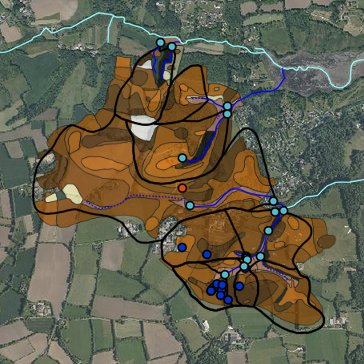
Le site de Kerbernez est localisé dans le sud du Finistère et occupe une surface de 1.28 km². Il est composé de 6 bassins de premier ordre et d’un bassin du deuxième ordre : Nead Meur (0.135 km²), Pont Lenn (0.117 km²), Coat Timon (0.57 km²), Le Puits (0.37 km²), Kerbernez (0.12 km²), Kerrien (0.095 km²). Les deux derniers sont des sous bassins du Puits. L’altitude varie entre 10 et 55 m NGF, avec des pentes modérées (moins de 7%) mais localement parfois supérieures à 15%. Les différents cours d’eau se jettent dans l’Odet 10 km avant son embouchure dans l’Atlantique.
-
L’entité bocagère de la Zone Atelier Armorique (ZAAR) est située au niveau du canton de Pleine-Fougères (depuis 1993). La zone bocagère est caractérisée par un gradient paysager allant d’un bocage dense avec des parcelles petites bordées de haies à un bocage lâche. Les haies bordant les parcelles sont le plus souvent constituées d’arbres émondés en ragosses, de chênes avec parfois quelques châtaigniers émondés et des chênes en haut jet, mais aussi de cépées de châtaigniers. Depuis 2005, en raison de l’introduction de conditions de protection de l’environnement dans la Politique Agricole Commune, la plupart des cours d’eau sont bordés de bandes enherbées.
-
Informations créées dans le cadre du volet cartographie (IGCS) du programme Sols de Bretagne. Coordonné par L'Institut Agro Rennes-Angers (2005-2010), ce programme a notamment pour objectifs de compléter et d'organiser les informations sur les sols bretons.
-
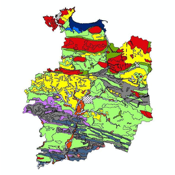
Carte pédologique de Pipriac au 1/25000. La codification correspond au code 4 critères des sols du Massif armoricain (voir ressources en ligne). Les champs de la table attributaire sont : - SUB : Matériau(x) parental(aux) à partir du(des)quel(s) se développe(nt) le sol - HYD : Classe d'hydromorphie, de 0 (sol bien drainé) à 9 (sol extrêmement hydromorphie) - TYPE : Développement de profil défini à partir de la succession des horizons - PROF : Profondeur du sol, classée de 1 (sols très épais) à 6 (sols superficiels) - CODE4C : code 4 critères issu de la concaténation des champs précédents. Les valeurs prises par les différents champs pour chaque entité sont détaillées dans la méthode 4 critères (voir ressources en ligne). - UTS : Numéro d'Unité Typologique de Sol issue du Référentiel Régional Pédologique de Bretagne.
-
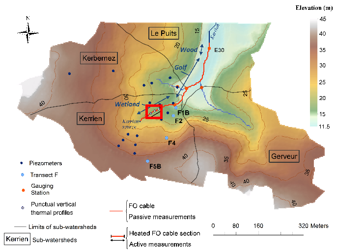
Data corresponding to the active-DTS experiment conducted in Kerrien by deploying and burying an heatable FO cable in the streambed sediments (in the wetland area). Further details are available in the file: http://agrhys.fr/BVE/nataline/mesuresactives/infos.pdf and results are presented in Simon et al. (2021)
-
Des stations de mesure en continu de paramètres hydrologiques, physiques, chimiques et sédimentaires ont été installées sur le fleuve Sélune, dans le cadre du programme scientifique de suivi de l’arasement des barrages de la Sélune. Les mesures sont acquises avec une fréquence au moins horaire depuis au plus 2014. Depuis 2019, ces stations relèvent de l'Observatoire Sélune, qui est en charge du suivi des paramètres environnementaux (biotiques et abiotiques). Les paramètres physico-chimiques mesurés comportent sur toutes les stations : la turbidité, le niveau d’eau, la conductivité. Sur certaines des stations, le pH et l’oxygène dissous ou la concentration en chlorophylle sont mesurés en plus. Cette couche donne les mesures brutes, issues des stations de mesure hydrologique
-

Les flux hydrologiques, sédimentaires fins et grossiers, et chimiques sont fortement impactés par la présence des barrages, alors que ces paramètres jouent un rôle majeur sur la qualité des habitats pour les communautés aquatiques. leur suivi sur le long terme est primordial dans le cadre d’une opération de restauration écologique après effacement de barrages. De plus sur la Sélune, le démantèlement s’accompagne d’une gestion spécifique des sédiments pour éviter un transfert massif de sédiments vers l’aval. Le transport des sédiments grossiers est étudié à l’aide de galets marqués par des transpondeurs passifs (pit tags). Ces pit tags ont été introduits dans plusieurs centaines de galets de différentes tailles du fleuve. Leurs déplacements au cours du cycle hydrologique sont suivis à l’aide d’une antenne que l’on déplace manuellement en parcourant la rivière, à raison d’une campagne par an. Cette couche donne les localisations des secteurs d'étude utilisés dans le suivi du transport des sédiments grossiers.
-
L’effacement des barrages de la Sélune fait l’objet d’un programme scientifique initié en 2012 dans lequel des paramètres environnementaux sont suivis afin de fournir un réel retour d’expérience sur cette opération de restauration. En 2019 s’est mis en place un observatoire de données, chargé d’assurer la collecte et le traitement de ces paramètres (biotiques et abiotiques). Avec l’arasement du barrage de La Roche Qui Boit (LRQB), il est vraisemblable que les sables, qui sont actuellement stoppés par le barrage, poursuivront leur transit vers l’aval. Afin de quantifier le mode de transit des sables nous allons suivre la granulométrie et la progression des sables à l’aval de LRQB à différents endroits. Des pièges à sédiment sont positionnés pour analyser l’évolution des tailles des sables suivant la distance au barrage de LRQB. L’objectif de ces pièges est de suivre l’évolution de la granulométrie charriée par le cours d’eau, et de rendre compte d’une possible évolution granulométrique des sédiments, avec l’apparition de sables transportés à l’aval des barrages. Ces dispositifs ne consistent pas à quantifier les flux sédimentaires avec plus de précision. Cette couche donne la localisation des secteurs d'étude utilisés dans le suivi du transport des sables, réalisé dans le cadre de l'Observatoire Sélune.
-
Le rétablissement du continuum fluvial de la Sélune après l’arasement des barrages permettra la colonisation de l’amont du bassin anciennement inaccessible aux anguilles. Avant l'arasement, deux affluents principaux étaient utilisés par les poissons amphihalins pour leur reproduction, en plus du cours principal : le Beuvron et l'Oir. La population d’anguille de la Sélune a été suivie en phase pré-arasement par des campagnes d’indice d’abondance effectuées en 2013, 2015, 2019, 2021 et 2023 sur un réseau de stations couvrant l’ensemble du réseau hydrographique de la Sélune. Ces données permettent d’estimer l’évolution de l’abondance des anguilles le long de la Sélune et de ses affluents et leur structuration en taille avant et après la destruction des barrages. L’inventaire est réalisé début septembre, une année sur deux, à l'aide d'un dispositif de pêche électrique et d'épuisettes. Trente points de pêche de trente secondes minimum sont réalisés. Une station de pêche comprend environ 100 mètres de linéaire de cours d’eau. Toutes les anguilles pêchées sont anesthésiées et font l’objet de mesures biométriques (poids, longueur, diamètre oculaire horizontal, vertical, détermination du stade jaune ou argentée). L’ensemble des anguilles est relâché directement sur le site de pêche. Cette couche contient les données individuelles sur les anguilles capturées.
-
L’effacement des barrages de la Sélune a pour objectif de restaurer les écosystèmes aquatiques dans le bassin versant et les populations animales et végétales aquatiques. Une des conditions du succès de l’opération est la réapparition de formes fluviales diversifiées et d’habitats aquatiques diversifiés. Idéalement, le cours d’eau reprendrait son tracé et sa dynamique initiale. Cependant, la nécessaire gestion des sédiments a impliqué des interventions humaines de degrés variables selon les secteurs, avec des conséquences probables sur la morphologie du cours d’eau (sinuosité, géométrie) et sur la nature du substrat du lit (granulométrie). La lamproie marine et le saumon, candidats à la recolonisation, façonnent le substrat des cours d’eau en construisant des nids où ils déposent et recouvrent leurs œufs. Cette activité peut significativement et durablement modifier la répartition des sédiments dans les zones de reproduction et augmenter la complexité des habitats aquatiques. Le projet « rôle des espèces ingénieures dans la restauration des habitats » étudie l’influence de ces deux espèces de poissons migrateurs sur la mobilité des sédiments et la morphologie du cours d’eau dans leurs zones de reproduction. Comprendre le rôle de ces espèces est important pour suivre la restauration de la vallée de la Sélune après sa remise en continuité et le retour des grands migrateurs. Cette couche donne la localisation des secteurs d'étude utilisés dans le cadre du projet de recherche "Espèces ingénieures" ("rôles des espèces ingénieures dans la restauration des habitats").