 OSURIS
5000
GEMET keywords
Type of resources
Available actions
Topics
INSPIRE themes
Keywords
Contact for the resource
Provided by
Years
Formats
Representation types
Update frequencies
status
Scale
-
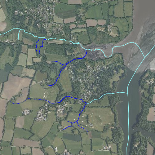
Représentation du réseau hydrographique sur la zone d'étude INRA de Kerbernez. Certains cours d'eau n'appartenant pas à la zone d'étude ont été représentés pour une meilleure compréhension du réseau. Les cours d'eau représentés en pointillés sont des cours d'eau alimentés moins de huit mois dans l'année, en traits pleins les cours d'eau alimentés plus de huit mois dans l'année. Le réseau hydrographique a été redessiné à partir d'une couche vecteur réalisée par Samuel Abiven (ABIVEN. S., 2000) et de l'ortho-photographie IGN. Les tracés ont été approuvés par Laurent Ruiz. Le code hydrographique a été renseigné à partir de la base de données Carthage.
-
Les données correspondent aux centroïdes des 40 parcelles agricoles en agriculture biologique et conventionnelle, suivies dans le projet DIVAG en 2019 dans la Zone Atelier Armorique Sud au Sud de l'Ille et Vilaine. Les données produites sont une couche vecteur polygone des points (contenant leurs coordonnées géographiques) correspondant aux centroïdes des parcelles. Programme de financement : projet DIVAG (Zone Atelier Armorique).
-
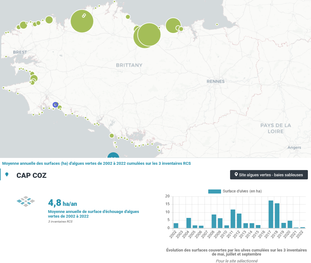
Le CEVA a été chargé, de 2002 à 2006, de la mise en place puis de la réalisation du suivi du phénomène de « marées vertes » à l’échelle de la Bretagne, dans le cadre du programme Prolittoral, programme régional et interdépartemental de lutte contre les marées vertes (financement de l’Agence de l’Eau Loire Bretagne, du Conseil régional de Bretagne et des quatre Conseils généraux bretons). Dans ce cadre, le CEVA a développé des outils spécifiques pour évaluer le phénomène et son évolution. Ces outils ont été élaborés en partant de la connaissance du phénomène acquise au travers des suivis antérieurs, réalisés pour le compte du Conseil général des Côtes d’Armor, de l’Agence de l’Eau Loire Bretagne et de collectivités locales bretonnes particulièrement touchées par le phénomène. Depuis 2007, le CEVA réalise les inventaires de marées vertes du Réseau de Contrôle de Surveillance (RCS) dans le cadre de la Directive Cadre sur l’Eau (DCE) pour l’évaluation des masses d’eau côtières et de transition, financée par l’Agence de l’Eau Loire Bretagne. Trois survols sont réalisés chaque année (mai, juillet, septembre) de l’ensemble du littoral (du Mont Saint Michel à l’île de Ré) faisant l’objet de l’acquisition de photographies aériennes à partir desquelles des surfaces d’échouages d’ulves sont mesurées. Pour les sites de type « sableux » classés « site à échouage d’ulves », l’estimation surfacique des échouages d’ulves en lame est réalisée pour chaque inventaire. Pour les sites de type « vaseux » marqués par un tapis continu d’algues vertes, toutes les surfaces couvertes par les algues vertes (filamenteuses ou en lames) sont estimées uniquement pour l’inventaire présentant un maximal annuel de biomasse. Cela fait suite à la mise au point des grilles de classement européennes de la DCE des masses d’eau de type « abritées » (vasières) en 2008.
-

Relevés phyto-sociologiques sur les bas-marais du Couesnon Voir : LANOÉ, E., 2008. Diagnostics phyto-écologique et paysager des marais de la basse vallée du Couesnon et de leur rôle fonctionnel potentiel en terme d’accueil de l’avifaune. Mémoire de master, Université de Rennes 1, Rennes, 42 p.
-
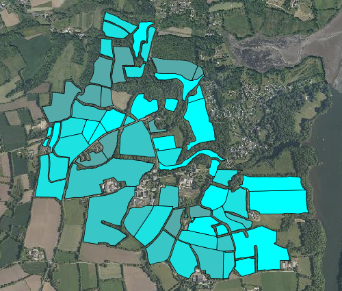
Carte du bilan en azote des parcelles du site d'étude INRA de Kerbernez. Le bilan azoté est renseigné de 1992 à 2005 et s'exprime en kg d'azote par hectare La couche vecteur a été crée à partir des données et des calculs de Laurent RUIZ et de la carte du découpage parcellaire réalisée par Samuel Abiven (ABIVEN. S., 2000)
-

Carte habitats semi-naturels sur les bas-marais du Couesnon Voir : LANOÉ, E., 2008. Diagnostics phyto-écologique et paysager des marais de la basse vallée du Couesnon et de leur rôle fonctionnel potentiel en terme d’accueil de l’avifaune. Mémoire de master, Université de Rennes 1, Rennes, 42 p.
-

Des bornes géodésiques ont été installées le long du cours principal de la Sélune. Matérialisées physiquement sur le terrain, ces bornes ont été localisées avec un GPS de haute précision (les précisions planimétriques et z sont données dans la table). Attention, ces bornes peuvent légèrement bouger avec les cycles d'humection/dessèchement des sols principalement argileux et leurs coordonnées pourront être réactualisées le cas échéant. Les bornes géodésiques peuvent servir de repères pour définir un dispositif ou un nouveau secteur d'étude.
-
L’objectif des auteurs était de cartographier et suivre la disparition de zones humides à une échelle fine en couplant des données LiDAR et des photographies aériennes historiques basées sur une typologie fonctionnelle qui identifie les zones humides potentielles, effectives, efficaces et dégradées. https://link.springer.com/article/10.1007/s13157-017-0985-2
-
Projet Fleur 2015-2018 : données décembre 2015- mars 2018 Echantillonnage de pucerons et de leurs ennemis naturels dans les champs de céréales et deux types d'habitats adjacents, marges herbeuses et bandes fleuries semées. Echantillonnage en période hivernale de Décembre à Mars. Dans la culture : échantillonnage de pucerons parasités et non parasités par relevé exhaustif de surface de 15m² proche bandes herbeuses et proche bandes fleuries.
-
Trente fenêtres paysagères (1km x 1km) ont été sélectionnées pour représenter la diversité du paysage du bassin versant du Couesnon tout en maximisant l’indépendance de quatre gradients décrivant la structure du paysage: deux gradients pour l’hétérogénéité du paysage, (i) hétérogénéité de composition, (ii) hétérogénéité de configuration, et deux gradients pour les quantités d’habitats semi-naturels, (iii) pourcentage de prairies, et (iv) pourcentage de haies (Figure 2). Les 30 fenêtres ont été sélectionnées sur la base d'autres critères qui limitent la probabilité de choisir des paysages atypiques : chaque fenêtre présentait ainsi moins de 2% de zone urbanisée ou d'habitats rares, au moins 5% de prairies, et au moins 1% de haies. Pour s'assurer que les sites sélectionnés étaient représentatifs du paysage environnant et pour éviter tout effet de bordure majeur, nous avons comparé la surface par type d'occupation du sol dans le paysage de 1km x 1km avec une zone plus grande (2km x 2km) centré sur chaque site et nous avons vérifié que les deux paysages (1kmx 1km versus 2 km x 2km) présentaient moins de 10% de différence entre chaque occupation du sol. Dans chaque fenêtres sont relevés plusieurs indicateurs: occupation du sol, climat, relevés biodiversité