 OSURIS
scientific ecology
GEMET keywords
Type of resources
Available actions
Topics
INSPIRE themes
Provided by
Years
Formats
Representation types
Update frequencies
status
Scale
-
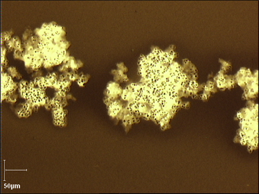
This is a data set on some morphological and physiological impacts of salinity on two isolated of Microcystis aeruginosa performed in laboratory experiments in the spring of 2022. Two non axenic isolated colonial Microcystis aeruginosa strains (PMC1323.21 and PMC1262.20) were used for the experiments. Both strains were provided by the Paris Museum Collection (PMC). For these experiments, colonies of both strains were grown in BG11 medium in Erlenmeyer flasks and kept in an exponentially growing phase. The batch cultures were stored in a growing chamber at 22 °C and under a light intensity of 40 μE/m2/s with a photoperiod of 14h/10h. For details see Bormans et al 2023 in MicrobiologyOpen This data set contains the following sheets: read_me cell_diameter_strain_1323.21 cell_diameter_strain_1262.20 volume_colonies_7d_strain_1262.20 volume_colonies_3d_strain_1262.20 autofluorescence 1323.21 autofluorescence 1262.20 intercellular spacing 1262.20
-
Sub-dataset dealing with occurence (presence/absence) of 26 vascular plant species surveyed in three hedgerow networks of the LTSER Zone Atelier Armorique (DEIMS.ID : https://deims.org/31e67a47-5f15-40ad-9a72-f6f0ee4ecff6). Vegetation was sampled in 25 m long quadrats (one quadrat per margin) placed in the middle of the field margin or stream bank (N= 242) to avoid edge effects from connection with other field margins. Presence–absence of 26 vascular plant species of the herb layer vegetation was recorded. The 26 plant species were selected because they were common, readily identifiable and represent a large range of characteristics: in taxonomy, morphology and life history. Vegetation surveys were conducted in 1994, 1998, 2001, 2007, 2011, 2013 and 2015 exclusively between May 15 and August 15. Nomenclature of vascular plants is according to the Flora Europaea (Tutin et al., 1993).
-
Dataset dealing with exhaustive vascular plant surveys (except in 2014) in the centre of 20 crop fields of the LTSER Zone Atelier Armorique (DEIMS.ID : https://deims.org/31e67a47-5f15-40ad-9a72-f6f0ee4ecff6). All vascular understory plants were sampled in 10 50cm x 50 cm plots located along a transect placed in the middle of the crop field. Sampled plots are 5 m apart from each other. The taxonomic standardization was based on Flora europaea (Tutin et al., 1993). Some taxa were identified only to genus as their identification at the seedling stage may show great discrepancy between observers. Field work was carried out from May to July. Note that not all crop fields were surveyed in 2015.
-
Dataset dealing with exhaustive vascular plant surveys in field margins of three hedgerow networks of the LTSER Zone Atelier Armorique (DEIMS.ID : https://deims.org/31e67a47-5f15-40ad-9a72-f6f0ee4ecff6). All vascular understory plants were sampled in 25 m long plot (one plot per field margin) placed in the middle of the field margin to avoid multiple edge effects from connection with other field margins. To incorporate local heterogeneity in field margin structure, all the width of field margins (N= 341) was sampled. Abundance-dominance of plants was scored using an ordinal scale according to Tansley (Tansley, 1935). The taxonomic standardization was based on Flora europaea (Tutin et al., 1993). Some taxa were identified only to genus as their identification at the seedling stage may show great discrepancy between observers. Field work was carried out from May to July for the two vegetation surveys (1994, 2015).
-

Abstract This site provides the global geographical distribution of gorse (Ulex europaeus) in introduced areas. We provide the xls files with all data in the standardized Darwin Core format, the map and the corresponding files. Coordinate points are provided in decimal degrees (latitude, longitude) and correspond to the confirmed existence of Ulex europaeus between 1950 and 2018. The dataset is a compilation of several sources, online databases (including GBIF and iNaturalist), scientific papers, personal communications, and prospecting by the authors (in the field or through online visual searches). The data were verified and duplicates were removed. More details are provided in Christina et al., 2020. The resulting dataset comprises 14,053 occurrences. The geo-located points are classified according to the administrative boundaries of the countries or islands in which they are located, except for Europe. For Europe, refer to the GBIF database. To view the interactive map, go to WMS and click on “add to map” or "visualiser" below. Résumé Distribution géographique de l'ajonc Ulex europaeus à l’échelle mondiale au format Darwin Core. Les points de coordonnées sont en degrés décimaux (latitude, longitude), ils correspondent à l’existence avérée d’un individu d'Ulex europaeus entre 1950 et 2018. Le jeu de données est une compilation de plusieurs sources, banques de données en ligne (dont GBIF, iNaturalist), articles scientifiques, communications personnelles et prospection par les auteurs (sur le terrain ou par recherche visuelle en ligne). Les données collectées ont été nettoyées, vérifiées, et les doublons éliminés. Tous les pays ou régions ayant référencé de l’ajonc sont répertoriés, sauf la zone native (Europe). Le jeu de données obtenu comprend 14053 occurrences. Les points géo-localisés sont classifiés selon les limites administratives des pays ou îles dans lesquels ils sont situés. Pour l'Europe, se reporter à la base GBIF. Afin d'afficher la carte interactive, aller sur WMS et cliquer plus bas sur 'add to map' ou 'visualiser'. Data verification and accuracy Several methods were used: visual checks on geolocated images (for data from citizen science), elimination of outliers (e.g., those located in the sea) or irrelevant data (in museums, centroids of administrative regions or large vector objects, etc.). For the data selected, maximum accuracy was sought by cross-referencing multiple sources of information (literature, observations, personal communications, geolocated images). The accuracy of the geolocations obtained is less than 100 meters for two-thirds of the points and less than 1 km for three-quarters of the points. Vérification et précision des données Plusieurs méthodes ont été utilisées : vérifications visuelles sur images géo-localisées (pour les données issues des sciences citoyennes), élimination des points aberrants (par exemple ceux localisés dans la mer), ou non-pertinents (dans des Muséums, centroïdes de régions administratives ou d’objets vectoriels de grande taille…). Pour les données retenues, la précision maximale a été recherchée en recoupant de multiples informations (littératures, observations, communications personnelle, images géolocalisées). La précision des géolocalisations obtenues est inférieure à 100 mètres dans les deux-tiers des points, inférieur au km pour les trois quarts des points. Christina M., *Limbada F., Atlan A. 2020. Climatic niche shift of an invasive shrub (Ulex europaeus). Journal of Plant Ecology. rtz041, https://doi.org/10.1093/jpe/rtz041 Programme ANR MARIS : Management and risk analysis of an invading plant species (ulex europaeus (L.): how socio-ecological niche with population dynamics modelling under a wide range of climates can help. ANR reference : ANR-14-CE03-0007