 OSURIS
25000
GEMET keywords
Type of resources
Available actions
Topics
INSPIRE themes
Keywords
Contact for the resource
Provided by
Years
Formats
Representation types
Update frequencies
status
Scale
-
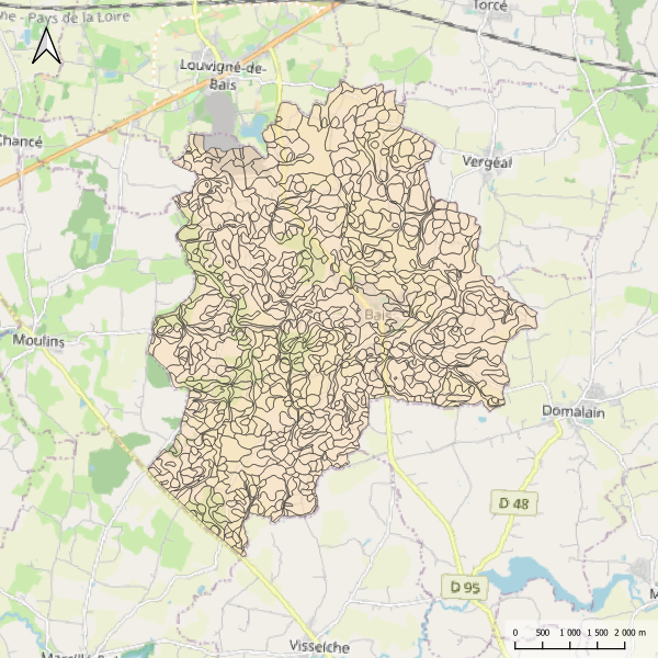
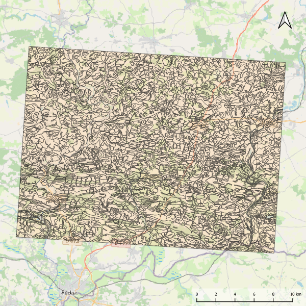
Carte pédologique de Bais au 1/25000. La codification correspond au code 4 critères des sols du Massif armoricain (voir ressources en ligne). Les champs de la table attributaire sont : - SUB : Matériau(x) parental(ux) à partir du(des)quel(s) se développe le sol - HYD : Classe d'hydromorphie, de 0 (sol bien drainé) à 9 (sol extrêmement hydromorphie) - TYPE : Développement de profil défini à partir de la succession des horizons - PROF : Profondeur du sol, classée de 1 (sols très épais) à 6 (sols superficiels) - CODE4C : code 4 critères issu de la concaténation des champs précédents. Les valeurs prises par les différents champs pour chaque entité sont détaillées dans la méthode 4 critères (voir ressources en ligne). - UTS : Numéro d'Unité Typologique de Sol issue du Référentiel Régional Pédologique de Bretagne.
-
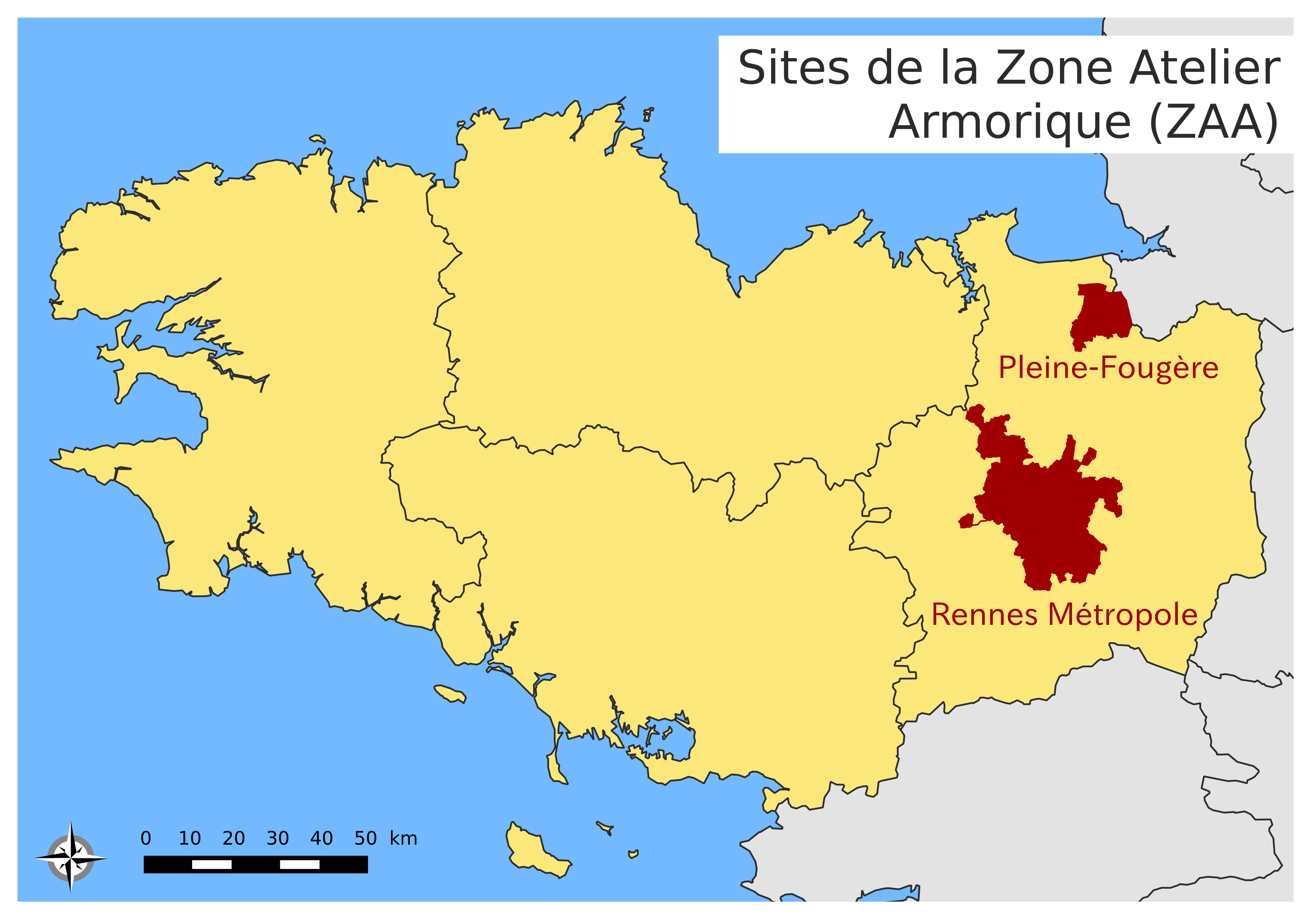
Le site urbain de la Zone Atelier Armorique ZAAr (parfois désigné par "Site de Rennes-Métropole"). Les types de paysages sont des systèmes urbains, des systèmes bocagers plus ou moins dégradés et des systèmes de zones humides.
-
Registre Parcellaire Graphique anonymisé d'Ille et Vilaine et rotations culturales de 2006 à 2014. La rotation culturale indiquée correspond à celle de la parcelle principale de chaque ilot déclaré à la PAC en 2014. Travail réalisé par l'UMR AGIR INRA et l'ODR INRA. Un identifiant non signifiant permet de retrouver les ilots d'une même exploitation.
-
Représentation du contour du bassin versant du site de Naizin dans le Morbihan dans le cadre de l'Observatoire de Recherche en Environnement (ORE) AgrHyS de l'INRAE. Cette couche spatiale a été calculée à partir du Modèle Numérique de Terrain Mégalis à 20 m. de résolution. Ce contour correspond au bassin versant de 12km2 du cours d'eau du Coetdan, le sous bassin sur lequel les observations hydrochimiques sont concentrées depuis 1993 se situe dans les 5km2 amont.
-
Le jeu de données comprend la vitesse de décomposition en milieux aquatique, terrestre humide et terrestre sec dans la forêt de Villecartier pour 18 espèces d'arbres (..........................................). Les caractéristiques chimiques (composition élémentaire C,N,P; teneur en phénol/polyphénol, cellulose, hémicellulose, métaboliques secondaires, terpènes, micronutriments) ainsi que leurs caractéristiques physiques (dureté, épaisseur, SLA, capacités de retention en eau) ont également été mesurées. De plus, la colonisation par les invertébrés et la biomasse microbienne (par mesure de respiration par la méthode SIR) ont été mesurées dans chaque milieux et pour chaque type de feuille. Des données sur les communautés d'invertébrés et les conditions climatiques (température, hygrométrie) des sites sont également disponibles
-
Carte pédologique de Pipriac au 1/25000. La codification correspond au code 4 critères des sols du Massif armoricain (voir ressources en ligne). Les champs de la table attributaire sont : - SUB : Matériau(x) parental(aux) à partir du(des)quel(s) se développe(nt) le sol - HYD : Classe d'hydromorphie, de 0 (sol bien drainé) à 9 (sol extrêmement hydromorphie) - TYPE : Développement de profil défini à partir de la succession des horizons - PROF : Profondeur du sol, classée de 1 (sols très épais) à 6 (sols superficiels) - CODE4C : code 4 critères issu de la concaténation des champs précédents. Les valeurs prises par les différents champs pour chaque entité sont détaillées dans la méthode 4 critères (voir ressources en ligne). - UTS : Numéro d'Unité Typologique de Sol issue du Référentiel Régional Pédologique de Bretagne.
-

Des stations de mesure en continu de paramètres hydrologiques, physiques, chimiques et sédimentaires ont été installées sur le fleuve Sélune, dans le cadre du programme scientifique de suivi de l’arasement des barrages de la Sélune. Les mesures sont acquises avec une fréquence au moins horaire depuis au plus 2014. Depuis 2019, ces stations relèvent de l'Observatoire Sélune, qui est en charge du suivi des paramètres environnementaux (biotiques et abiotiques). Les paramètres physico-chimiques mesurés comportent sur toutes les stations : la turbidité, le niveau d’eau, la conductivité. Sur certaines des stations, le pH et l’oxygène dissous ou la concentration en chlorophylle sont mesurés en plus. Cette couche donne les mesures corrigées, issues des stations de mesure hydrologique SIGNY, LA-ROCHE-QUI-BOIT, VIREY et DORIERE (uniquement jusque octobre 2020).
-
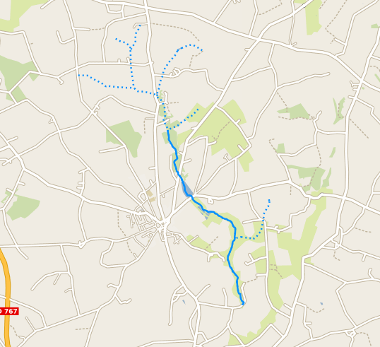
Représentation des tronçons hydrographiques du bassin versant du site de Naizin dans le Morbihan dans le cadre de l'Observatoire de Recherche en Environnement (ORE) AgrHyS de l'INRAE. Cette couche spatiale est extraite du jeu de données des tronçons hydrographiques de France métropolitaine BD Topage® version 2019. Le tronçon hydrographique est le découpage le plus fin d'un réseau hydrographique. Il peut composer un cours d'eau ou traverser un plan d'eau. Il correspond au concept « WatercourseLink » d'Inspire.
-
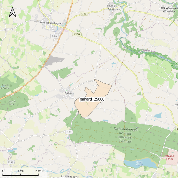
Emprise de la carte pédologique de Gahard au 1/25000. La donnée de base, au format image scannée, n'est pas publiée.
-
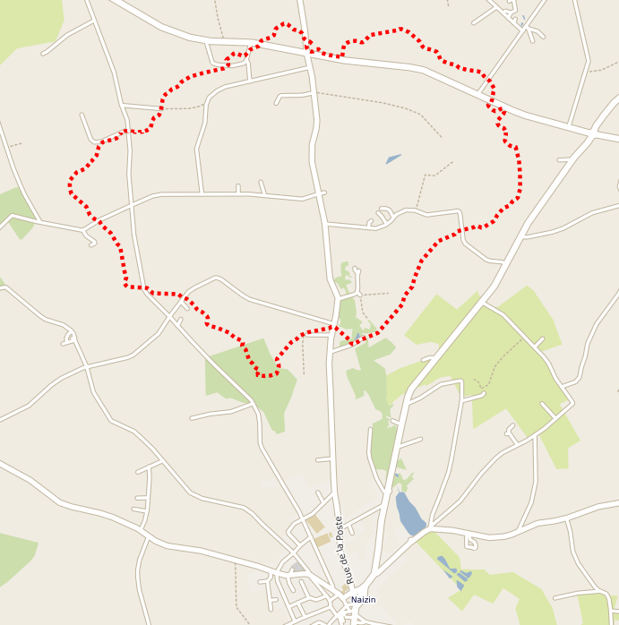
Représentation du contour du bassin versant de Kervidy à l'amont du site de Naizin dans le Morbihan. Naizin est une des 2 sites de l'Observatoire de Recherche en Environnement (ORE) AgrHyS de l'INRAE. Traitement réalisé à partir du Modèle Numérique de Terrain de Mégalis à 20 m. de résolution. Ce contour correspond au bassin versant de 5km2 du cours d'eau du Coetdan, bassin sur lequel les observations hydrochimiques sont concentrées depuis 1993.