 OSURIS
location
GEMET keywords
Type of resources
Available actions
Topics
INSPIRE themes
Keywords
Contact for the resource
Provided by
Years
Formats
Representation types
Update frequencies
status
Scale
Resolution
-

The evolution of infrastructure networks such as roads and streets are of utmost importance to understand the evolution of urban systems. However, datasets describing these spatial objects are rare and sparse. The database presented here represents the road network at the french national level described in the historical map of Cassini in the 18th century. The digitalization of this historical map is based on a collaborative platform methodology that we describe in detail. These data can be used for a variety of interdisciplinary studies, covering multiple spatial resolutions and ranging from history, geography, urban economics to the science of network. (2015-01-15)
-
Dans le cadre du projet Biomonitoring et de l'observatoire Sélune ont été disposées des stations pilotes le long du cours principal de la Sélune, réparties de l’amont à l’aval des barrages hydroélectriques. Trois stations se situent dans les anciennes retenues des barrages, les deux autres, dites de référence, sont hors zone d'influence des anciens barrages (l'une étant en aval et l'autre en amont). Dans ces stations, les biocénoses aquatiques (incluant macroinvertébrés benthiques, biofilms, macrophytes...) sont suivies. 2 campagnes d'échantillonnage (printemps et automne) de macroinvertébrés benthiques (mib) sont réalisées depuis septembre 2014. Lors de chaque campagne, 2 protocoles d'échantillonnage sont mis en oeuvre : - suivant la norme NF T90-333 qui permet le calcul de l'IBG-DCE et l'I2M2 ("SURBER") - via des substrats artificiels immergés pendant 1 mois ("SUBART"), afin de se focaliser sur la mesure de « l’effet des barrages ». Le protocole est décrit dans : Piscart C., Moreteau, J.C., Beisel J.N. (2006). Monitoring changes in freshwater macroinvertebrate communities along a salinity gradient using artificial substrates. Environmental Monitoring and Assessment 116: 529-542. Cette couche détaille les taxons de macroinvertébrés benthiques et leurs abondances obtenus après analyse (selon la norme NF T90-388). Ces données sont distribuées par campagne et par secteur. Les taxons présentant l’ensemble des critères morphologiques clairement visible et caractéristique permettant l’exactitude de leur détermination et un état de conservation irréprochable sont intégrés à la collection de référence de l’Observatoire Sélune. Celle-ci est consultable sur demande (cf. point de contact). La détermination des taxons s'appuie sur la version v17 de la référence TAXREF. Le jeu de données est actuellement sous embargo.
-
Cette ressource indique la position GPS du réseaux de piézomètre du site d'étude du Cô- Malville (Bassin versant du Ninian - Ploermel (56)) dans le cadre du projet BERCEAU. Elle indique les coordonnées géographiques des piézomètres sous forme de données vectorielles (shapefile).
-

Les communautés microbiennes jouent un rôle majeur dans le fonctionnement des écosystèmes : elles sont à la base de la chaîne alimentaire (production primaire) et participent à la dégradation de la matière organique. Ces communautés sont, de plus, connues pour répondre rapidement à des changements environnementaux. Elles peuvent être utilisées comme indicateurs écologiques, à l'instar des macro-invertébrés. Les diatomées benthiques sont les organismes photosynthétiques majoritaires au sein de cette communauté biologique. L’abondance relative des différentes espèces permet de calculer un indice de qualité du milieu (IBD). Des fortes différences de communautés entre les zones amont et aval ont été constatés quand les barrages étant en place. Elles seront amenées à évoluer après l’effacement de ces barrages. Dans le cadre de l'observatoire Sélune ont été disposées des stations pilotes le long du cours principal de la Sélune, réparties de l’amont à l’aval des barrages hydroélectriques. Trois stations se situent dans les anciennes retenues des barrages, les deux autres, dites de référence, sont hors zone d'influence des anciens barrages (l'une étant en aval et l'autre en amont). Dans ces stations, les biocénoses aquatiques (incluant macroinvertébrés benthiques, biofilms, macrophytes...) sont suivies. Depuis septembre 2014, les stations sont idéalement échantillonnées tous les mois d’Avril à Octobre (7 relevés annuels) à l'aide de substrats artificiels (lames de verre disposées dans l'eau). En plus du relevé des diatomées (liste floristique, calcul de l'IBD), la concentration en chlorophylle-a est mesurée. Lors de chaque campagne, un protocole d'échantillonnage expérimental INRAe est mis en oeuvre. Ce protocole implique des dispositifs d'immersion (1 mois) de lames de verre, une mesure in situ de concentration en chlorophylle-a via BentoTorch puis une récolte du biofilm sur ces lames de verre. Le biofilm est conditionné dans (1) dans de l'éthanol à 99.9% pour la détermination des IBDs et des listes floristiques (prestation externalisée, s'appuyant sur la norme NF T90-354) et (2) dans de l'eau minérale pour mesure de concentration de la chlorophylle-a via spectromètre. La détermination des taxons s'appuie sur la version v17 de la référence TAXREF. Le jeu de données est actuellement sous embargo.
-

Les macrophytes sont un ensemble de plantes aquatiques. Elles se situent à la base de la chaine alimentaire et peuvent fournir un habitat à de nombreuses autres espèces. L’abondance relative des différentes espèces permet de calculer un indice de qualité du milieu (IBMR). Dans le cadre de l'observatoire Sélune ont été disposées des stations pilotes le long du cours principal de la Sélune, réparties de l’amont à l’aval des barrages hydroélectriques. Trois stations se situent dans les anciennes retenues des barrages, les deux autres, dites de référence, sont hors zone d'influence des anciens barrages (l'une étant en aval et l'autre en amont). Dans ces stations, les biocénoses aquatiques (incluant macroinvertébrés benthiques, biofilms, macrophytes...) sont suivies. Les paramètres suivis sont la composition spécifique et le recouvrement, sur 8 stations du cours principal situées à l’amont, à l’aval et sur les zones néo-lotiques des communautés de macrophytes. La fréquence du suivi consiste en une campagne annuelle pour les stations hors retenues (S0, S1 et S5) et deux campagnes annuelles (printemps/automne) pour les stations néo-lotiques (S2, S3.4, S4.1 et S6). Le protocole mis en œuvre est le protocole d’échantillonnage des macrophytes et bryophytes suivant la norme NF T90-395 (octobre 2003) qui définit l’IBMR. Les taxa sont prélevés pour être identifiés en laboratoire. Cette couche donne la valeur de l'indice IBMR et EQR (normé) à une station pour une campagne ainsi que les informations concernant la robustesse de cet indice, les quantités de taxons utilisés pour le calcul de ces indices mais également des informations en terme de proportion de grands groupes floristiques (heterotrophes, algues, bryophytes, pteridophytes, helophytes, phanerogrames, végétation flottante et végétation immergée).
-

Dans le cadre de l'observatoire Sélune ont été disposées des stations pilotes le long du cours principal de la Sélune, réparties de l’amont à l’aval des barrages hydroélectriques. Trois stations se situent dans les anciennes retenues des barrages, les deux autres, dites de référence, sont hors zone d'influence des anciens barrages (l'une étant en aval et l'autre en amont). Dans ces stations, les biocénoses aquatiques (incluant macroinvertébrés benthiques, biofilms, macrophytes...) sont suivies. Les paramètres suivis sont la composition spécifique et le recouvrement, sur 8 stations du cours principal situées à l’amont, à l’aval et sur les zones néo-lotiques des communautés de macrophytes. La fréquence du suivi consiste en une campagne annuelle pour les stations hors retenues (S0, S1 et S5) et deux campagnes annuelles (printemps/automne) pour les stations néo-lotiques (S2, S3.4, S4.1 et S6). Le protocole mis en œuvre est le protocole d’échantillonnage des macrophytes et bryophytes suivant la norme NF T90-395 (octobre 2003) qui définit l’IBMR. Les taxa sont prélevés pour être identifiés en laboratoire. Cette couche donne La détermination des taxons s'appuie sur la version v17 de la référence TAXREF. Le jeu de données est actuellement sous embargo.
-
Les communautés microbiennes jouent un rôle majeur dans le fonctionnement des écosystèmes : elles sont à la base de la chaîne alimentaire (production primaire) et participent à la dégradation de la matière organique. Ces communautés sont de plus connues pour répondre rapidement à des changements environnementaux. Elles peuvent être utilisées comme indicateurs écologiques, à l'instar des macro-invertébrés. Les diatomées benthiques sont les organismes photosynthétiques majoritaires au sein de cette communauté biologique. L’abondance relative des différentes espèces permet de calculer un indice de qualité du milieu (IBD). Des fortes différences de communautés entre les zones amont et aval ont été constatés quand les barrages étant en place. Elles seront amenées à évoluer après l’effacement de ces barrages. Dans le cadre de l'Observatoire Sélune, les stations sont échantillonnées tous les mois d’Avril à Octobre (7 relevés annuels) à l'aide de substrats artificiels (lames de verre disposées dans l'eau). En plus du relevé des diatomées (liste floristique, calcul de l'IBD), la concentration en chlorophylle a est mesurée. Cette couche donne la valeur de l'indice IBD et EQR (normé) à une station pour une campagne.
-
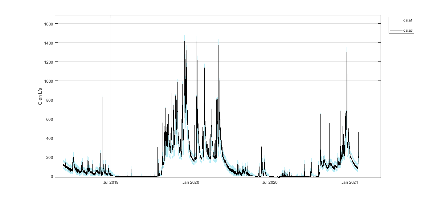
Données des niveaux limnimétriques enregistrés dans le réseau de piézomètre du site de restauration du Ruisseau du Cô-Malville, bassin versant du Ninian - Ploërmel (56). Débits minimums, optimaux et maximum calculés à partir de la courbe de tarage construite sur les différentes sections limnimétriques du site d'étude et des incertitudes qui lui sont associées.
-

Les communautés microbiennes jouent un rôle majeur dans le fonctionnement des écosystèmes : elles sont à la base de la chaîne alimentaire (production primaire) et participent à la dégradation de la matière organique. Ces communautés sont, de plus, connues pour répondre rapidement à des changements environnementaux. Elles peuvent être utilisées comme indicateurs écologiques, à l'instar des macro-invertébrés. Les diatomées benthiques sont les organismes photosynthétiques majoritaires au sein de cette communauté biologique. L’abondance relative des différentes espèces permet de calculer un indice de qualité du milieu (IBD). Des fortes différences de communautés entre les zones amont et aval ont été constatés quand les barrages étant en place. Elles seront amenées à évoluer après l’effacement de ces barrages. Dans le cadre de l'observatoire Sélune ont été disposées des stations pilotes le long du cours principal de la Sélune, réparties de l’amont à l’aval des barrages hydroélectriques. Trois stations se situent dans les anciennes retenues des barrages, les deux autres, dites de référence, sont hors zone d'influence des anciens barrages (l'une étant en aval et l'autre en amont). Dans ces stations, les biocénoses aquatiques (incluant macroinvertébrés benthiques, biofilms, macrophytes...) sont suivies. Depuis septembre 2014, les stations sont idéalement échantillonnées tous les mois d’Avril à Octobre (7 relevés annuels) à l'aide de substrats artificiels (lames de verre disposées dans l'eau). En plus du relevé des diatomées (liste floristique, calcul de l'IBD), la concentration en chlorophylle-a est mesurée. Lors de chaque campagne, un protocole d'échantillonnage expérimental INRAe est mis en oeuvre. Ce protocole implique des dispositifs d'immersion (1 mois) de lames de verre, une mesure in situ de concentration en chlorophylle-a via BentoTorch puis une récolte du biofilm sur ces lames de verre. Le biofilm est conditionné dans (1) dans de l'éthanol à 99.9% pour la détermination des IBDs et des listes floristiques (prestation externalisée, s'appuyant sur la norme NF T90-354) et (2) dans de l'eau minérale pour mesure de concentration de la chlorophylle-a via spectromètre. NB : l'année 2023 n'est pas couverte en matière de mesure de concentration en chlorophylle-a via Spectrométrie suite à un problème de conservation basse température des échantillons. Ce jeu de données propose les mesures de concentration moyenne journalière de chlorophylle-a et de phéopigment en µg/cm2/jour
-
Données des niveaux piézométriques et limnimétriques enregistrés dans le réseau de piézomètre du site de restauration du Pas de l'Âne, bassin versant de la Flume à Vignoc (35)