 OSURIS
environmental impact
GEMET keywords
Type of resources
Available actions
Topics
INSPIRE themes
Provided by
Years
Formats
Representation types
Update frequencies
status
Scale
-

The dataset includes BLUM and long base tiltmeter data.
-
The dataset includes BLUM and long base tiltmeter data.
-
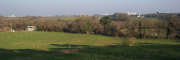
The Ploemeur-Guidel observatory (Britanny, France) is focusing on surface-depth relationships in a fractured crystalline geological context and oceanic climate. It is built on 2 sub-sites, one highly anthropized, the other in natural state. In Ploemeur, groundwater has been pumped since 1991, supplying more than 1 million m3 of clean drinking water annual at a sustainable rate. Such high productivity is explained the specific fractured network in granite and micaschists, draining deep geological layers (~400 m). Extracted water quality is very good, with limited nitrate concentration, in a region that has been strongly affected by widespread pollution. Guidel site is in a similar, but natural context. Deep iron-rich groundwater is upflowing, creating surface and deep groundwater-dependent ecosystems, and feeding a classified coastal wetland. Both sites have a very dense equipment to study rapid to long-term surface-depth exchanges: a flux tower, unsaturated zone monitoring, a network of ~50 shallow (<10m) and deep boreholes (>80m), hydrochemical, temperature and deformation. An well-characterized fractured experimental site offers the possibility to conduct experiments to test innovative instruments and develop new methodologies
-

This borehole hydrogeophysical logging data include optical imaging,acoustic logging,induction and electrical resistivity,natural and spectral gamma radioactivity,fiber optic measurements an d multiparameter probe logs.
-
This borehole hydrogeophysical logging data include optical imaging,acoustic logging,induction and electrical resistivity,natural and spectral gamma radioactivity,fiber optic measurements and multiparameter probe logs.
-
This dataset includes vadose zone data (temperature,water content and suction) and flux tower data (air pressure,air specific humidity,air temperature,co2 flux,evapotranspiration,h2o flux,latent heat flux,wind direction,wind speed).
-
This borehole hydrogeophysical logging data include optical imaging,acoustic logging,induction and electrical resistivity,natural and spectral gamma radioactivity,fiber optic measurements an d multiparameter probe logs.
-
This borehole hydrogeophysical logging data include optical imaging,acoustic logging,induction and electrical resistivity,natural and spectral gamma radioactivity,fiber optic measurements an d multiparameter probe logs.
-
This borehole hydrogeophysical logging data include optical imaging,acoustic logging,induction and electrical resistivity,natural and spectral gamma radioactivity,fiber optic measurements an d multiparameter probe logs.
-
This borehole hydrogeophysical logging data include optical imaging,acoustic logging,induction and electrical resistivity,natural and spectral gamma radioactivity,fiber optic measurements an d multiparameter probe logs.